


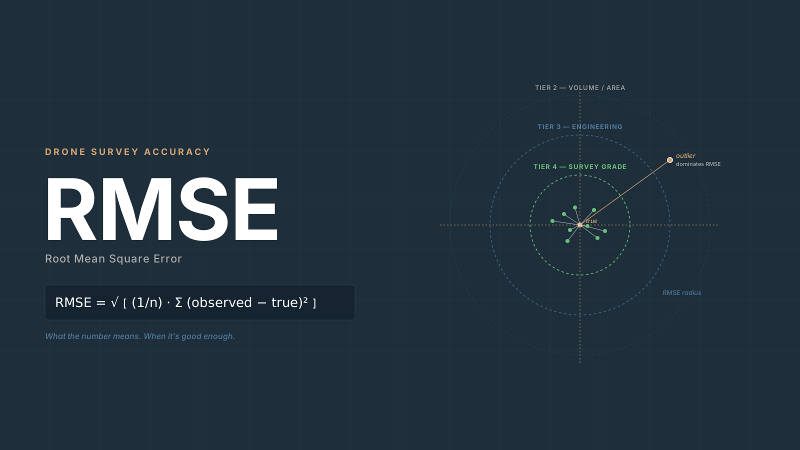
Your quality report says RMSE 0.07 ft. The engineer on the phone asks if that’s good enough. Can you answer without hesitating?
Most drone operators can’t. Root Mean Square Error (RMSE) shows up in every Pix4D, Metashape, and DJI Terra quality report, but the number gets copy-pasted into deliverables without a real grasp of what it represents, when it’s defensible, or how it compares to the spec the client actually has in mind.
Here is what RMSE actually is, why the formula is what it is, which numbers measure accuracy versus the ones that only look like they do, why vertical is always worse than horizontal, how to convert to CE90, LE90, and NSSDA format when a client asks, and a four-tier framework for deciding when a result is good enough for the job in front of you.
What RMSE Actually Measures
For a set of n checkpoints:
RMSE = √[ (1/n) × Σ(observed − true)² ]
In drone survey terms, “observed” is the coordinate the photogrammetric model assigns to a checkpoint. “True” is the independently surveyed coordinate of that same physical target.
For the three axes:
RMSEx = √[ (1/n) × Σ(X_check − X_true)² ]
RMSEy = √[ (1/n) × Σ(Y_check − Y_true)² ]
RMSEz = √[ (1/n) × Σ(Z_check − Z_true)² ]

RMSEr (horizontal/radial) = √(RMSEx² + RMSEy²)
(RMSEr and RMSEz are Edition 1 notation, retained inside formula blocks throughout this article; Edition 2 uses RMSEH for horizontal RMSE and RMSEV for vertical RMSE.)
The result is in the same units as your coordinates — feet if you’re working in a state plane system with US survey feet.
In plain English: take every checkpoint, square the distance between where the model says it is and where it actually is, average those squared values, then take the square root. A horizontal RMSE (RMSEH) of 0.05 ft means the model is typically within about half a tenth of a foot of true horizontal position. It is not a maximum error — it’s a weighted statistical summary where larger errors count more than small ones.
Why Squaring Matters
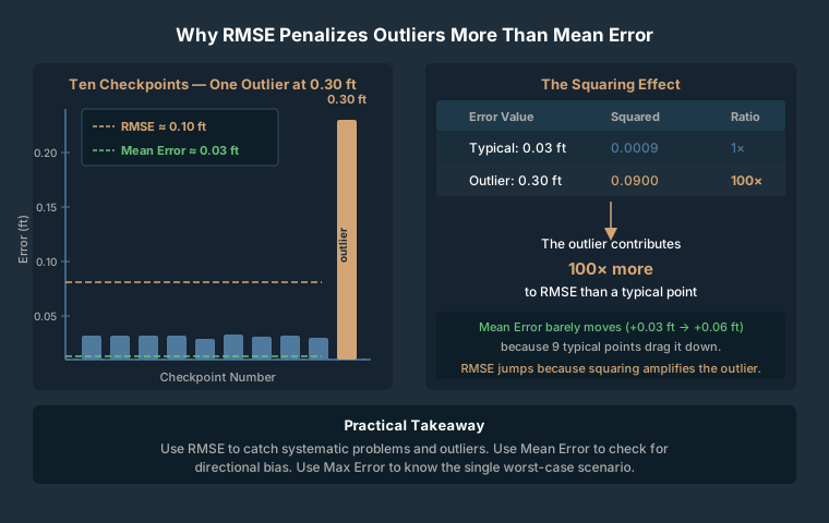
The squaring step is not arbitrary. Compare three metrics on a dataset where nine checkpoints are within 0.03 ft and one outlier is 0.30 ft off:
- Mean error (bias): Averages to near zero because positive and negative deviations cancel. Useful for detecting systematic shifts; blind to random blunders.
- Mean Absolute Error (MAE): Treats all errors equally. The outlier barely moves the average.
- RMSE: 0.30² = 0.09 versus 0.03² = 0.0009. That outlier contributes 100 times more to the calculation than a typical point.
That asymmetry is intentional for survey work. A single large blunder in a stockpile surface can corrupt a volume calculation, and you want the metric to flag it. Use all three numbers together: mean error tells you about systematic shift, RMSE tells the accuracy story, and max error tells you what you’d need to explain.
The Only Honest Number: Checkpoints, Not GCP Residuals
This is the most practically important distinction in drone survey accuracy, and it gets ignored constantly.
Ground Control Point (GCP) markers are fed into the processing software. Bundle adjustment bends the model geometry to fit them. Their residuals in the quality report show how well the model fits the control — not how accurate the deliverable is.
Checkpoints (sometimes called independent validation points) use the same kind of physical targets with known coordinates, but they are withheld from processing entirely. The model has never seen them. Checkpoint-derived RMSE is the only independently validated accuracy statement you can make.
If a quality report shows only GCP residuals and no checkpoint RMSE, there is no independent accuracy validation. Full stop.
For any deliverable where accuracy matters, you need checkpoints. The American Society for Photogrammetry and Remote Sensing (ASPRS) Edition 2, Version 2 (2024) sets a 30-checkpoint floor for full certification (capped at 120) — a tighter requirement than the 2014 standard, which scaled checkpoint count by project area without a flat minimum at that number. For the full breakdown of ASPRS accuracy classes and what each tier means in centimeters, see the drone survey accuracy guide. For smaller projects, use as many as the site allows — three to five checkpoints on a small site is far better than zero.
Why Vertical Accuracy Is Always Worse
Vertical RMSE (RMSEV) in drone photogrammetry is consistently 2 to 3 times worse than RMSEH. The ratio holds across drone types, software platforms, and project scales. It is not a calibration problem. It is inherent to how photogrammetry reconstructs 3D geometry from images taken by a downward-looking camera.
Four reasons:
Nadir geometry. A camera pointed straight down captures excellent horizontal information in every overlapping image. Depth (Z) is inferred from parallax — the small positional shift of a feature between overlapping frames. Small errors in camera position or calibration amplify vertically, not horizontally.
GNSS geometry. Vertical positioning from GNSS is weaker than horizontal by design. GPS satellites orbit around the horizon; none sit directly below. Vertical Dilution of Precision (VDOP) is always worse than Horizontal DOP.
Surface reconstruction. Point cloud generation handles textured features — edges, corners, contrasted surfaces — well. Smooth horizontal planes like pavement or bare soil have less photogrammetric texture, which makes Z reconstruction noisier.
GCP lever-arm effects. A GCP with a small horizontal placement error produces a proportionally larger rotational error in the vertical direction when it constrains bundle adjustment.
Accept the ratio as a given. If you’re hitting 0.07 ft horizontal, expect 0.12 to 0.20 ft vertical unless conditions are particularly favorable.
Real-World Benchmarks by Configuration
Typical achievable accuracy varies by ground control strategy and whether the drone carries a Real-Time Kinematic (RTK) receiver. The Ground Sample Distance (GSD) — the real-world distance represented by one image pixel — is the reference unit most accuracy thresholds scale against.
| Configuration | RMSEH | RMSEV |
|---|---|---|
| Consumer GPS only, no GCPs | 3–10 ft (1–3 m) | 6–25 ft (2–8 m) |
| Handheld GPS GCPs (3–15 ft GPS) | 3–8 ft (1–2.5 m) | 6–20 ft (2–6 m) |
| Surveyed GCPs, RTK rover, 5+ GCPs | 0.05–0.15 ft (1.5–4.5 cm) | 0.08–0.25 ft (2.4–7.6 cm) |
| RTK drone, no GCPs, optimal | 0.07–0.20 ft (2–6 cm) | 0.10–0.35 ft (3–10 cm) |
| RTK drone + 1–3 check GCPs (hybrid) | 0.03–0.10 ft (1–3 cm) | 0.05–0.20 ft (1.5–6 cm) |
A note on the handheld GPS row: using consumer GNSS — a phone, a Garmin handheld — to set GCPs does not improve your model’s absolute accuracy. The software will fit the model to those GCPs precisely, and the result will be precisely wrong.
As a general rule of thumb with properly surveyed GCPs and adequate overlap (75% frontal, 65% side or better):
RMSEH ≈ 1–2 × GSD
RMSEV ≈ 2–3 × GSD
At 1-inch GSD — typical at 250 to 350 ft AGL with a 20 MP sensor — target RMSEH of 1 to 2 inches and RMSEV of 2 to 3 inches.
CE90, LE90, and NSSDA — When Clients Ask for a Different Number
CE90 and LE90
CE90 (Circular Error 90%) is the radius of a circle within which 90% of measured horizontal positions fall. LE90 (Linear Error 90%) is the vertical distance within which 90% of elevations fall.
CE90 = 1.5175 × RMSEr    (horizontal; Edition 1 notation — RMSEr ≡ RMSEH in Edition 2)
LE90 = 1.6449 × RMSEz    (vertical;   Edition 1 notation — RMSEz ≡ RMSEV in Edition 2)
Quick reference:
| RMSEH | CE90 | RMSEV | LE90 |
|---|---|---|---|
| 0.05 ft | 0.076 ft | 0.06 ft | 0.099 ft |
| 0.10 ft | 0.152 ft | 0.10 ft | 0.164 ft |
| 0.20 ft | 0.304 ft | 0.20 ft | 0.329 ft |
NSSDA Accuracy Statements
The National Standard for Spatial Data Accuracy (NSSDA) is the federal standard used by USGS, FEMA, and most federal agencies. It expresses accuracy at 95% confidence.
NSSDA Horizontal = 1.7308 × RMSEr    (95% confidence, circular normal)
NSSDA Vertical   = 1.9600 × RMSEz    (95% confidence, linear)
Common practitioner error: using 1.96 for both. The 1.96 is the 95th percentile z-score for a one-dimensional normal distribution — it applies to the vertical component only. The horizontal component uses 1.7308 because it’s a 2D circular distribution. If you’ve been using 1.96 for horizontal NSSDA statements, your reported number is about 13% too high.
Example: RMSEH = 0.07 ft, RMSEV = 0.12 ft:
Horizontal: 1.7308 × 0.07 = 0.121 ft → "Tested 0.12 feet horizontal accuracy at 95% confidence level"
Vertical:   1.9600 × 0.12 = 0.235 ft → "Tested 0.24 feet vertical accuracy at 95% confidence level"
The official NSSDA statement format per FGDC:
“Tested [X] feet horizontal accuracy at 95% confidence level.” “Tested [X] feet vertical accuracy at 95% confidence level.”
ASPRS Accuracy Standards: Edition 1 vs. Edition 2
Edition 1 (2014)
Three tiers relative to GSD:
- Class I: RMSE ≤ 1× GSD
- Class II: RMSE ≤ 2× GSD
- Class III: RMSE ≤ 4× GSD
Many contract specs from 2015–2022 reference this edition.
Edition 2, Version 2 (2024)
Edition 2 changed the framework significantly:
- No GSD-linked classes. Accuracy thresholds are independent of GSD.
- RMSE is the only required metric. CE90, LE90, and 95% confidence statements are no longer mandatory.
- User-specified classes. A project requiring 5 cm accuracy becomes “the 5 cm RMSEH Horizontal Positional Accuracy Class.”
- Checkpoint floor formalized at 30 (capped at 120). Edition 1 used a project-area-scaled count without a flat minimum at this number; Edition 2’s 30-point floor is a tighter, more defensible requirement.
- Checkpoint survey error is now explicitly accounted for in the final accuracy statement.
Edition 2 accuracy statement format:
“This data set was tested to meet ASPRS Positional Accuracy Standards for Digital Geospatial Data, Edition 2, Version 2 (2024) for a [X cm] RMSEH Horizontal Positional Accuracy Class.”
When Is Your RMSE Good Enough? A Four-Tier Framework
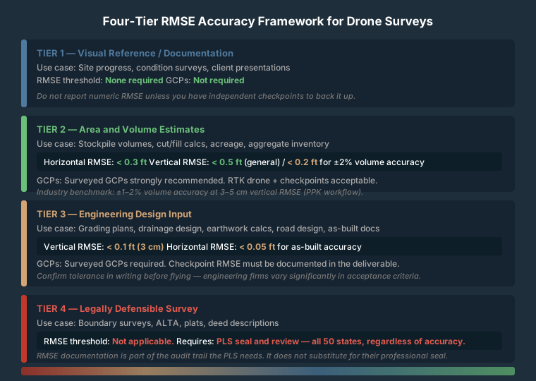
Tier 1 — Visual Reference and Documentation
Site progress photos, condition documentation, client presentations, before/after comparisons.
Threshold: None. GCP requirement: Not required.
Do not provide numeric RMSE values in deliverables for Tier 1 work unless you have independent checkpoints to back them up.
Tier 2 — Area and Volume Estimates
Stockpile volumes, cut/fill calculations, acreage calculations, aggregate inventory.
Threshold: RMSEH below 0.3 ft, RMSEV below 0.5 ft for general work. For stockpile volumes where ±2% accuracy matters, RMSEV should be below 0.2 ft.
GCP requirement: Surveyed GCPs strongly recommended.
Tier 3 — Engineering Design Input
Grading plans, drainage design, earthwork calculations, road design, as-built documentation.
Threshold: RMSEV below 0.1 ft (roughly 3 cm) for most engineering applications. RMSEH below 0.05 ft.
GCP requirement: Surveyed GCPs required. Checkpoint RMSE must be documented in the deliverable package.
Confirm the tolerance in writing before flying. Engineering firms vary significantly in what they’ll accept.
Tier 4 — Legally Defensible Survey
No matter how accurate the data is — 0.02 ft RMSE, perfectly validated — a drone dataset is not a legally defensible survey unless it is reviewed, verified, and sealed by a licensed Professional Land Surveyor (PLS). Boundary surveys, ALTA surveys, plats, and surveys referenced in deed descriptions require PLS oversight in all 50 states.
RMSE documentation is part of the audit trail a PLS needs. It does not substitute for their professional review and seal. See drone mapping and surveying legality for the full regulatory picture.
How to Report RMSE to a Client
Say: “Our checkpoint analysis shows horizontal accuracy of 0.08 ft and vertical accuracy of 0.14 ft, based on five independent checkpoints not used in processing. This exceeds the 0.1-ft vertical threshold your engineer specified.”
Not: “The accuracy is 0.08 feet” — that omits horizontal versus vertical and conflates checkpoints with GCP residuals.
Not: “Survey-grade accuracy” — the phrase has no agreed technical definition.
Any deliverable that is not signed and sealed by a PLS should carry this disclaimer:
“This deliverable is not a licensed survey. Positional accuracy is reported based on independent checkpoint analysis per [NSSDA / ASPRS Edition 2]. This data is intended for [stated purpose] and should not be used for legal boundary determination, deed description, or any purpose requiring a licensed survey.”
Frequently Asked Questions
My quality report shows GCP residuals of 0.02 ft. Can I report that as my accuracy?
No. GCP residuals show how well the software fit the model to the control it was given. They are not an independent accuracy measure. To report an accuracy number, you need checkpoints — targets with known coordinates that were withheld from processing entirely. Without checkpoints, you have no independent validation.
How many checkpoints do I need?
ASPRS Edition 2 sets the minimum at 30 for a statistically valid assessment, with a ceiling of 120 for very large projects. For smaller commercial jobs, use as many as you can reasonably deploy. Three to five well-distributed checkpoints on a small site is far better than zero and will surface major problems.
Why does my RTK drone still show vertical RMSE worse than horizontal?
Because the vertical/horizontal accuracy gap is a photogrammetric geometry issue, not an RTK hardware issue. RTK improves the absolute position of each image. But depth reconstruction from nadir imagery still relies on parallax, and the geometry of that computation is less precise in Z than X or Y. The 2–3× RMSEV-to-RMSEH ratio persists even with RTK drones.
A client’s spec says CE90 ≤ 0.15 ft. What RMSE do I need to hit?
Work backward: CE90 = 1.5175 × RMSEr (Edition 1 notation; Edition 2 uses RMSEH), so RMSEH = 0.15 ÷ 1.5175 = 0.099 ft. You need RMSEH below about 0.10 ft to meet that spec. Target 0.08 ft or better to have margin.
What’s the difference between NSSDA and ASPRS Edition 2 accuracy statements?
NSSDA (federal, FGDC) reports accuracy at 95% confidence using multipliers of 1.7308 (horizontal) and 1.9600 (vertical). It is required for FGDC-compliant federal deliverables. ASPRS Edition 2, Version 2 (2024) reports RMSE directly, with no confidence-level multiplier. For a government contract, check which standard the spec references — many federal contracts still require NSSDA format.
If I’m using an RTK drone, do I still need GCPs?
You still need independent checkpoints even if you don’t need GCPs for control. RTK improves the image geotag accuracy, which often reduces or eliminates the need for GCPs to constrain the model. But without independent checkpoints withheld from processing, you have no way to verify what accuracy you actually achieved. See ground control points for drone mapping for the full workflow.
Key Numbers Reference
| Conversion | Factor | Use |
|---|---|---|
| CE90 from RMSEr | × 1.5175 | RMSEH → CE90 (RMSEr is Edition 1 notation; ≡ RMSEH in Edition 2) |
| LE90 from RMSEz | × 1.6449 | RMSEV → LE90 (RMSEz is Edition 1 notation; ≡ RMSEV in Edition 2) |
| NSSDA Horizontal | × 1.7308 | RMSEH → 95% confidence statement |
| NSSDA Vertical | × 1.9600 | RMSEV → 95% confidence statement |
| Horizontal target | 1–2× GSD | With surveyed GCPs, good overlap |
| Vertical target | 2–3× GSD | With surveyed GCPs, good overlap |
| RMSEV / RMSEH ratio | 2–3× worse | Universal in drone photogrammetry |
| Engineering threshold | 0.1 ft vertical | Common in engineering contracts |
| Volume threshold | 0.2 ft vertical | Acceptable for ±2% volume accuracy |