


You’ve just produced a beautiful orthomosaic for a construction client. The aerial perspective is crisp. The colors are true. The alignment looks perfect. They use it to calculate earthwork volumes for a $2 million grading contract—and three months later, you receive a letter from your state’s Board of Examiners. The letter says you engaged in unlicensed surveying. The question isn’t whether your data was accurate. The question is whether you were legally allowed to produce it in the first place.
This is not legal advice. Consult an attorney licensed in your state before offering mapping services commercially.
That warning matters—not because the law is confusing, but because it varies sharply by state and enforcement is unpredictable. I’ll walk through what the law actually says about drone mapping, which states enforce most aggressively, what case law has established, and which business models keep you legal versus which ones get you a cease-and-desist letter.
Drone Mapping Regulation: Two Separate Regulators — FAA vs. States
Most drone operators get this wrong from the start: the FAA governs the flight. States govern the data.
Your Part 107 certificate means you can legally operate a drone commercially in U.S. airspace. It covers whether you can fly for money, where you can fly (altitude, airspace restrictions), how you must operate (VLOS, speed limits), and your medical fitness.
That’s it. The FAA doesn’t care what you do with the resulting imagery. Orthomosaics, 3D models, volumetric calculations, DEMs—the FAA has no authority over any of it. Part 107 says nothing about accuracy, coordinate systems, ground control points, or what you charge for.
State Professional Licensing Boards govern whether you need a license to produce surveying products. Definitions vary by state, but they typically cover products that determine boundaries, measure distances or elevations relative to a coordinate system, claim accuracy specifications, or produce contour lines, DEMs, or volume calculations.
A Part 107 certificate is not a surveying license. You cannot get licensed to do survey work by passing an FAA test. These are completely separate regulatory systems. You need both if your work crosses both lines—but most drone operations cross only the FAA line.
The gap between “I can legally fly this drone” and “I can legally sell the maps it produces” is where the legal exposure sits.
The Controlling Case: 360 Virtual Drone Services v. Ritter
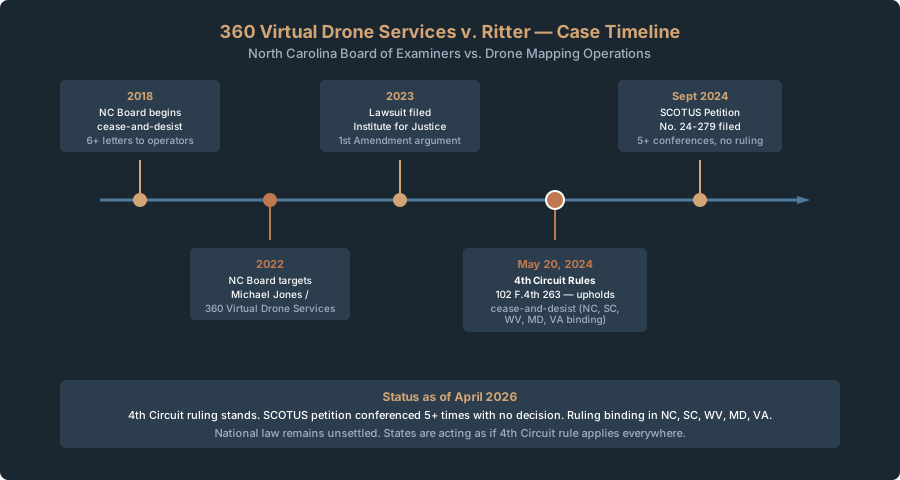
In May 2024, the U.S. Court of Appeals for the Fourth Circuit issued 360 Virtual Drone Services LLC v. Ritter, 102 F.4th 263 (4th Cir. May 20, 2024). It’s the first major federal ruling on drone mapping and surveying law, and it matters whether you’re in the Fourth Circuit or not.
What Happened
Michael Jones ran 360 Virtual Drone Services in North Carolina—orthomosaics, DEMs, volume calculations for construction companies, sold for profit. The North Carolina Board of Examiners sent him a cease-and-desist, claiming unlicensed surveying.
Jones sued on First Amendment grounds. His argument: the imagery and calculations were simply information—protected speech. If he couldn’t claim accuracy or liability for them, why did the state get to regulate what he published?
The Institute for Justice represented him.
The Court’s Decision
The Fourth Circuit upheld the cease-and-desist. The court applied intermediate scrutiny—does the regulation further an important government interest, and is it narrowly tailored?
The court found the state’s interest substantial: “In administering their licensing requirements for Professional Land Surveyors, States seek to protect the public from the harms that can arise from incompetent or unethical surveying work—such as incorrect boundary determinations, inaccurate land descriptions, and inadequate record keeping.”
The part that matters for drone operators is how the court characterized the work. The court held that the statute covers “maps or models of areas of land that contain measurable data” and described Jones’s products as “conduct that classically falls under the surveying profession.”
The practical question: Can someone extract measurements from your output?
I distill the court’s reasoning this way: if the output contains measurable spatial data—distances, elevations, coordinates—the state can regulate it. That’s my shorthand, not the court’s formal language, but it captures the functional line they drew. Georeferenced orthomosaics cross that line because someone can measure from them. So producing them requires a surveying license under North Carolina law.
Important distinction: the court did not rule that all aerial photography is surveying. Only that if the output has spatial data tied to a coordinate system—a product containing measurable data—the state can regulate it.
The SCOTUS Question
Jones appealed to the Supreme Court. SCOTUS Petition No. 24-279 was filed September 9, 2024. On April 20, 2026, the Supreme Court denied certiorari — letting the Fourth Circuit ruling stand. The Fourth Circuit decision binds NC, SC, WV, MD, and VA directly. Nationally, the denial means no federal precedent overrides it, and other circuits are free to adopt the same reasoning.
With SCOTUS declining review, the practical effect is that states can regulate georeferenced drone products as surveying under existing licensing statutes — and they are. Expect enforcement to expand, not contract.
The State-by-State Picture
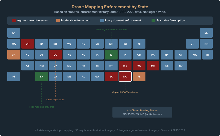
Forty-seven states regulate topographic mapping products (including LiDAR). Separately, 33 regulate authoritative imagery, 21 regulate georeferenced imagery, and 15 regulate GIS products. Enforcement intensity and definitional scope vary widely.
| State | Statute | Definition Breadth | Enforcement Level | Key Notes |
|---|---|---|---|---|
| North Carolina | N.C. Gen. Stat. Chapter 89C | Extremely broad — explicitly includes “photogrammetric surveying” | Very aggressive — 6+ cease-and-desist letters since 2018 | The test case. Board targets orthomosaics, DEMs, contour lines, stockpile volumes. Jones case originated here. |
| Oregon | ORS 672.028 | Includes “photogrammetric mapping registration” (separate license track) | Moderate — 2–3 cases per year | Common trap: people think “I’m not doing boundary work” so they don’t need a license. Oregon disagrees. |
| Colorado | C.R.S. 12-120-305 | Broad — tying any point to a coordinate system counts as surveying | Moderate — enforcement via criminal statute, not just civil cease-and-desist | First offense: Class 2 misdemeanor. Repeat: Class 6 felony. Fines $50–$5,000 per violation. |
| Illinois | 225 ILCS 330/1 | One of the few states with an explicit accuracy-threshold exemption — if accuracy is below NSPS (National Society of Professional Surveyors) standards, it’s generally not regulated | Low — almost no enforcement | The safe harbor: if you don’t claim survey-grade accuracy, you’re likely legal. Few other states publish a comparable threshold carve-out. |
| California | Professional Engineers Act & B&P Code 8700–8729 | Moderate — photography alone is not surveying; measured data is | Low–moderate — pursues a modest number of enforcement actions annually, typically driven by complaints from licensed surveyors | Complaint-driven. If you’re not upsetting competitors, you’re unlikely to be caught. |
| Texas | Occupations Code Chapter 1071 | Narrower — tied to boundary determination | Low — almost no enforcement for topographic mapping | Topo mapping is gray area. Boundary work is regulated. |
| Florida | F.S. Chapter 472 | Includes “photogrammetric survey work” in definition | Moderate — ~5–10 cases per year | Complaint-driven. Surveyors file against competitors. |
| New York | NY PRL Article 7 | Includes “surveying,” but defined narrowly around boundaries and property lines | Low–moderate — enforcement focused on boundary work | Topographic and engineering surveying are less regulated. |
The ASPRS (American Society of Photogrammetry and Remote Sensing) data, published in a 2022 LIDAR Magazine article citing ASPRS resources, breaks it down:
- 47 states regulate topographic mapping products (including LiDAR)
- 33 states regulate authoritative imagery
- 21 states regulate georeferenced imagery generally
- 15 states regulate GIS products
If you’re producing georeferenced data—orthomosaics, point clouds, DEMs—assume your state has a statute requiring a license. The real question is enforcement intensity. North Carolina and Oregon are aggressive. Most others are dormant.
What You Can Do Without a License
There are legitimate uses of drone mapping data that don’t require a Professional Land Surveyor (PLS) license. These are the safe zones.
Aerial photography for marketing or real estate. Raw aerial images are not surveying products. A photo isn’t “capable of measurement” unless you’ve tied it to a coordinate system. Selling aerial photos to a real estate agent is legal nationwide with Part 107.
Construction progress photos and video. Visual documentation—no measurements, no coordinates, no accuracy claims—is legal. You’re making a visual record, not a survey product.
Agricultural field photography and multispectral imagery. NDVI maps, multispectral analysis, crop monitoring photography—generally not regulated as surveying. Gray area in a few states, but enforcement is basically nonexistent.
Environmental monitoring and infrastructure inspection. Thermal roof inspections, erosion assessment, environmental site documentation—none of these are survey products unless you’re claiming accurate measurements.
Orthomosaics for visual reference with no accuracy claims. You can produce a georeferenced orthomosaic internally or deliver it with an explicit disclaimer: “For visual reference only. No accuracy is claimed.” Disclaimers reduce legal exposure—not eliminate it, but reduce it. North Carolina’s cease-and-desist letters target products presented as deliverables with implicit accuracy claims.
Working under a licensed surveyor’s responsible charge. If a PLS contracts you to fly, process the raw imagery, and deliver it to them for review, QA, and signature—you’re in the clear. The PLS takes professional responsibility. You’re the technician. This is the most common legal business model, and I’ll dig into it more below.
What You Cannot Do Without a License
Boundary surveys. All 50 states regulate boundary determination. You cannot survey property lines, prepare a plat, or establish boundary coordinates without a PLS license. Non-negotiable.
ALTA/NSPS Land Title Surveys. These are boundary surveys requiring a PLS to sign and seal. National standard. No license, no ALTA survey. Period.
Construction staking and layout. Determining where to place a building, foundation, or utility line using survey-grade coordinates requires a PLS.
Subdivision plats. Any legal document that subdivides land into lots requires a PLS to prepare, sign, and seal it.
Signing or stamping any survey document. Putting your professional seal on a survey document without a license is fraud. Full stop.
Volume calculations for contract payment. North Carolina specifically targets this. Calculating earthwork volumes or stockpile quantities that a contractor uses to bill for work—the state calls that surveying. Their reasoning: accurate volume calculations are tied to contract execution and payment fairness, so professional responsibility is required.
This is where most drone operators get caught. You fly a site, produce an orthomosaic and DEM, the construction PM calculates volumes from your data to pay a subcontractor—and suddenly you’ve produced a surveying product without realizing it.
The Gray Areas
Real-world drone mapping doesn’t fit neatly into “survey” and “not survey.” These are the zones where reasonable people disagree—and where your state’s enforcement approach matters more than the statute text.
Topographic Data for Engineering Design
Say you produce elevation contours or a DEM for an engineering firm designing a stormwater system. The contours feed into HEC-RAS. Does this require a PLS license?
Under the 360 Virtual reasoning, yes—you’re producing a product containing measurable data tied to a coordinate system.
In practice, most states don’t enforce this. The engineering firm uses your data as one input among many—no survey document, no field staking—and enforcement is rare. North Carolina is the exception.
Safe approach: Deliver the data with an accuracy statement. Let the engineer sign off on it. You’re the technician; they take professional responsibility.
Volume Calculations: Internal Use vs. Billing
You calculate stockpile volumes from your DEM. A contractor uses them to track inventory. Surveying?
For internal inventory tracking, most states won’t pursue. But contract payment volumes—determining how much a contractor gets paid for moving material—states call that surveying. North Carolina definitely does.
Safe approach: Make the DEM and orthomosaic available. Have the client or a PLS do the volume calculation and sign off on methodology.
Accuracy Claims
Saying “this orthomosaic is accurate to 1 meter” amplifies legal exposure. You’re explicitly claiming measurement capability. “For visual reference” reduces it—but doesn’t eliminate it under the 360 Virtual reasoning.
I use language like this: “This orthomosaic was produced from aerial imagery captured on [date] using standard photogrammetric processing. Accuracy depends on ground control point quality, GPS positioning, and processing parameters. Validate critical measurements with a licensed surveyor.”
The Measurable-Data Question
The practical takeaway from 360 Virtual is this: the court looks at whether the output contains measurable data—not what you claim, not what the client trusts, but whether someone could extract measurements from it. (Again, that’s my distillation of the court’s reasoning, not a formal named test—the court spoke in terms of “maps or models” containing “measurable data” and “conduct that classically falls under the surveying profession.”)
Under this reasoning, almost any georeferenced product is regulated. Orthomosaics, point clouds, even aerial images with GPS coordinates in the EXIF data. Once you’ve produced a georeferenced product, there’s almost no way around it. That’s what makes the ruling so aggressive.
The Insurance Gap Nobody Talks About
Your drone hull insurance and general liability cover physical damage and bodily injury. They do not cover errors & omissions (E&O) for surveying work.
I’ve read the exclusion language in multiple policies. It looks like this: “Coverage does not apply to any alleged incident arising from professional services, including but not limited to surveying, engineering, or design services.”
So you produce a georeferenced map. A client relies on it. The data is inaccurate. Your standard policy denies the claim. You’re uninsured.
E&O insurance for surveying exists—but requires a PLS license. Without one, E&O insurers deny claims for unlicensed practice. You’re liable with no coverage. A single bad project—inaccurate volume calculations in a $50,000 billing dispute—can sink you.
The Safe Business Model: Working Under Responsible Charge
The cleanest legal model for drone mapping is simple: you fly and process; a licensed surveyor reviews, validates, and takes professional responsibility.
“Responsible charge” is the statutory phrase. The PLS must:
- Genuinely review the work—not rubber-stamp it
- Validate the methodology and accuracy
- Sign and seal the final product (if it’s a formal survey document) or sign a cover letter stating professional responsibility
- Be available if disputes or errors arise
Under this model, you’re a technician working for a licensed professional. They hold the license and the liability.
What responsible charge does NOT require:
- The PLS on site during the flight—Boards accept remote supervision
- The PLS doing the processing—they review your work and validate outputs
- A formal survey document—they can deliver your DEM or orthomosaic with a professional cover letter
What responsible charge DOES require:
- Real technical review, not rubber-stamp signatures
- Documentation (notes, email, cover letter, QA report)
- The PLS understanding the data and methodology well enough to defend it
In practice, it works like this: you provide flight services and initial processing, the surveyor reviews and validates accuracy, then delivers to the client with professional responsibility. Their E&O insurance covers the work. You charge $300–800 per flight hour (standard range), the surveyor marks up the final deliverable, and everyone is legal, insured, and accountable.
Planning your flights and ground control for this model? Use the GSD Calculator to confirm your resolution meets the surveyor’s accuracy requirements, and the GCP Calculator to determine how many ground control points you need for the project area.
What This Means for This Series
Every article in this series teaches mapping skills that are legal for personal use, internal documentation, and working under professional oversight.
When I cover flight parameters, GCP deployment, software workflows, or deliverable types like orthomosaics and DEMs—I’m teaching you skills that produce defensible results when a licensed professional reviews your work.
I’m not teaching you to hang out a shingle as an independent drone-mapping surveyor. Most states prohibit that without a PLS license, and enforcement is increasing. What I am teaching is how to understand the technical capabilities and limits of consumer drone mapping, how to work confidently under a licensed professional’s oversight, and how to partner with surveyors and engineering firms in a way that’s legal, insurable, and profitable.
The law is a guardrail, not a barrier. Know where it is. Respect it. There’s real money in the technical space between the guardrails.
Bottom Line
FAA regulates the flight. States regulate the data. Part 107 and a PLS license are two separate gates—most drone operators only need Part 107. But if your work produces georeferenced data that clients use for financial or legal decisions, you need either a surveying license or a licensed surveyor reviewing and taking professional responsibility.
The law is state-specific and enforcement is unpredictable. One model is unambiguously legal everywhere: you fly, process, and deliver technical analysis; a licensed surveyor reviews, validates, and signs off. This is how the industry works at scale, and it’s how you build a business without regulatory risk.
The legal lines are real. They protect the public. Respect them, know where they are, and build profitable work within them.
Crawl 2 of the Consumer Drone Mapping Series, published April 2026. Every article that follows assumes you’ve read this one. Questions about surveying law in your state should go to a licensed attorney—not a drone forum.