
Photogrammetry
Point Cloud Classification: Ground, Vegetation & Buildings
Classify drone point clouds into ground/vegetation/buildings with Metashape, LAStools, PDAL, CloudCompare, ArcGIS Pro. Tool decision framework.
Read more →
Tag Archive
26 articles on drone mapping. Field-tested methodology from a GIS scientist with M.S. GIS, FAA Part 107, and 10+ years of geospatial work.
Classify drone point clouds into ground/vegetation/buildings with Metashape, LAStools, PDAL, CloudCompare, ArcGIS Pro. Tool decision framework.

A practitioner's guide to Agisoft Metashape processing settings: what each quality slider controls, why the tradeoffs matter, and three presets for real jobs.
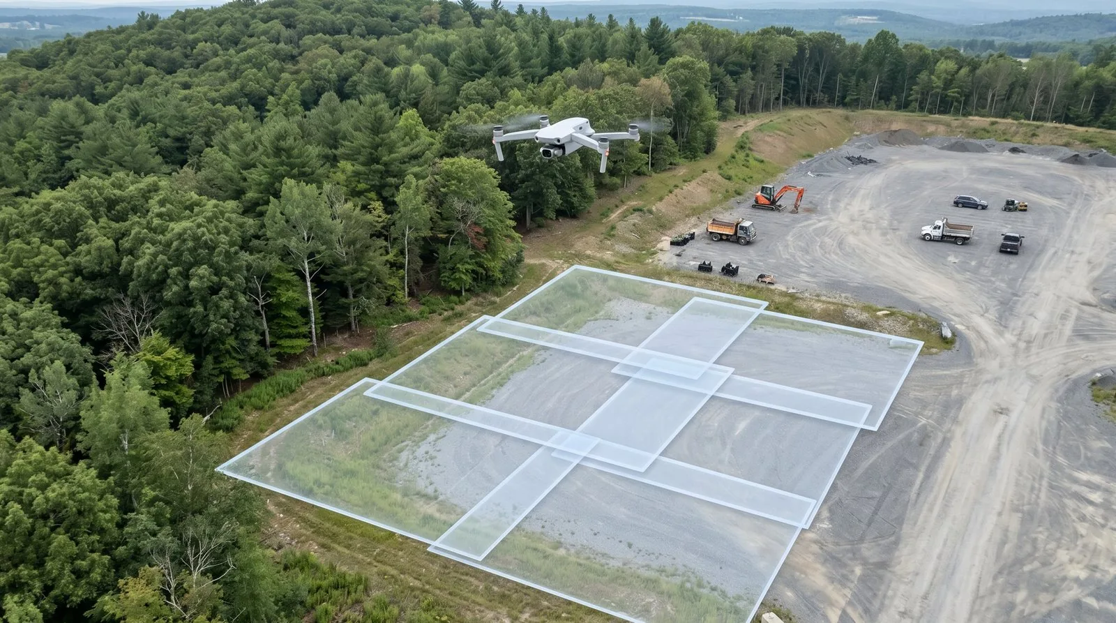
Image overlap drone mapping: 75/60 is the floor, not the target. Here's what fails when overlap is wrong and how to set photogrammetry overlap by job type.

Orthomosaic export settings, point cloud formats, DEMs, coordinate systems — and how to package drone deliverables so clients can actually use them.

The drone map doming effect causes systematic elevation errors up to 13 ft — and the orthomosaic looks fine. Here's how to detect, fix, and prevent it.

The drone mapping quality report looks reassuring — until a client finds 8-inch errors. Learn to read every Pix4D and Metashape number before delivery.

Drone mapping flight parameters: GSD, overlap, altitude, speed. 80% frontal / 70% side minimums. Accuracy improves 11x from 60% to 80% overlap.

3D Gaussian Splatting for drone operators: vs photogrammetry, accuracy benchmarks, software and pricing, hybrid workflow, what it cannot do.

Digital twin construction contracts pay $3K-15K/month recurring. The three-tier service model, CRS alignment, platforms, and how to win your first.

BVLOS is coming. Part 108 rules, waiver process, equipment, PPK workflows, and the crew-savings math for corridor and linear infrastructure.

NeRF vs photogrammetry for drone mapping: accuracy numbers, output products, georeferencing limits, and a decision framework for when each wins.

Drone processing checklist: CRS setup, alignment QA, GCP integration, checkpoint validation, quality report review. Prevents accuracy failures.

Consumer drone mapping buyer's guide: DJI Mini 4 Pro vs Mini 3 Pro vs Autel Evo Nano+. Accuracy, rolling shutter, GCP needs — field-tested verdicts.

Complete QGIS workflow for drone data: import orthomosaics, build pyramids, contours from DEMs, point clouds, QField field review. QGIS 3.44 LTR.
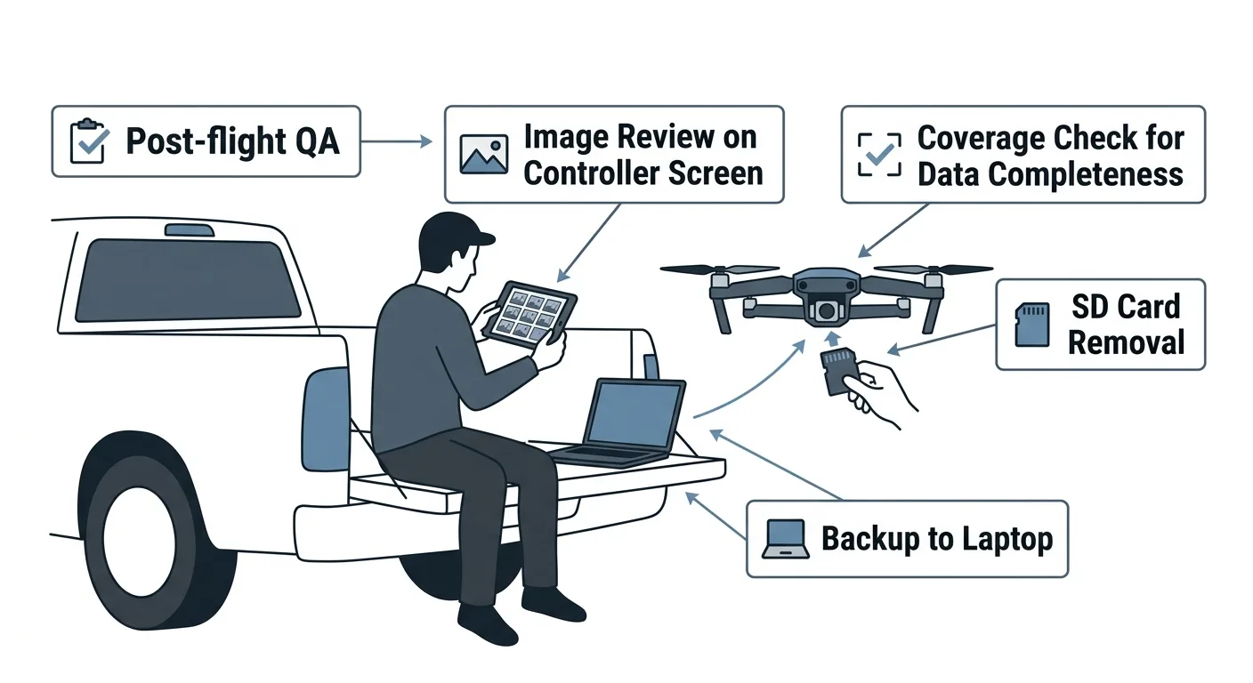
Post-flight QA checklist: image review, coverage verification, metadata validation, 3-2-1 backup. Part 4 of the drone mapping checklist series.

WGS84 vs NAD83, state plane, vertical datums — the CRS settings drone operators get wrong, and how to fix them in Metashape, Pix4D, and ODM.
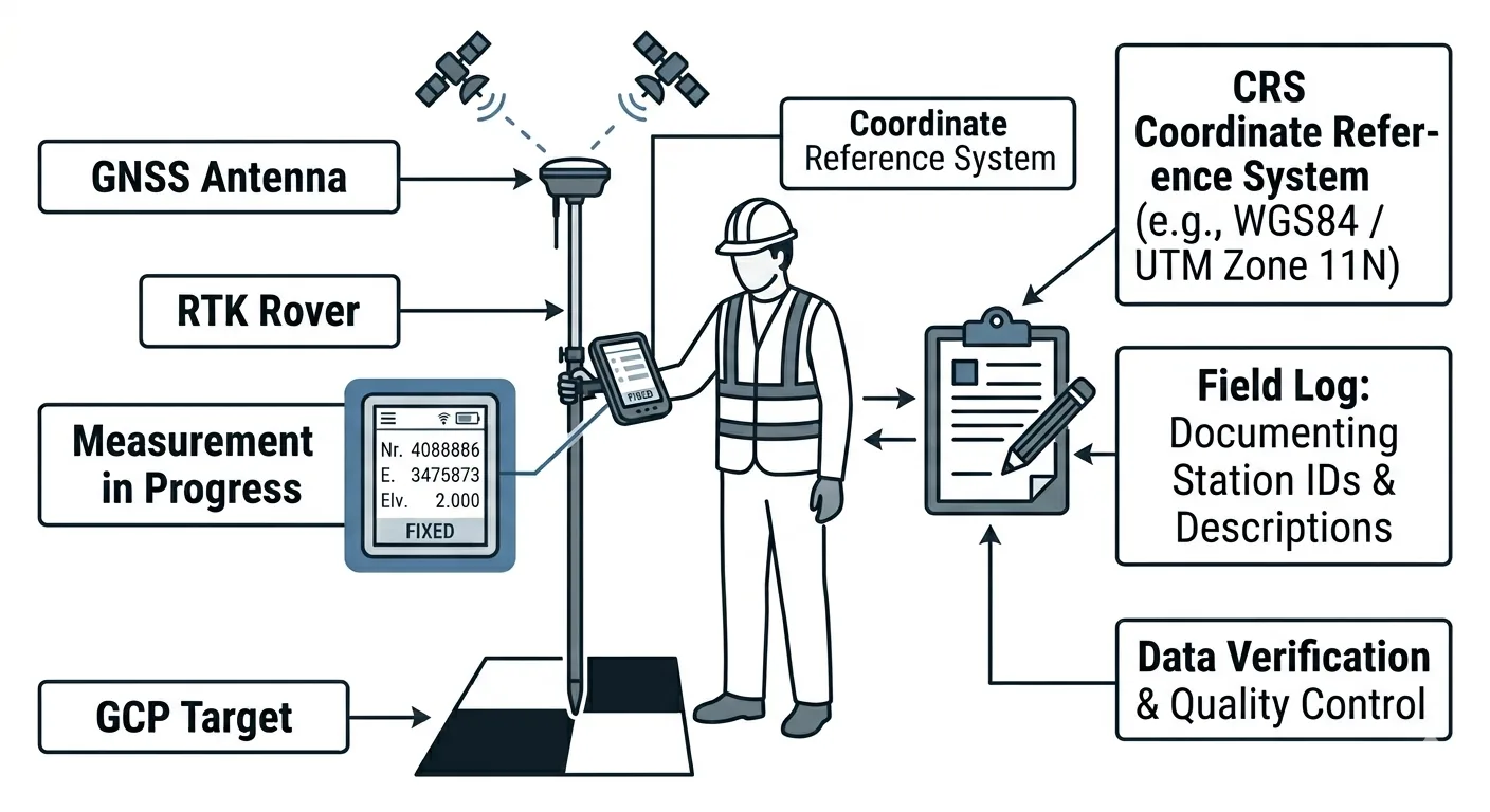
GCP deployment checklist: placement, measurement procedure, photo documentation, field logging. Every step from planning through pre-flight.

An orthomosaic is a georeferenced image mosaic built from overlapping drone photos. How photogrammetry creates one, GSD, GeoTIFF vs COG, GIS use.

DSM vs DTM vs DEM for drone operators: definitions, how each is derived from photogrammetry, ground classification, and when each product is required.
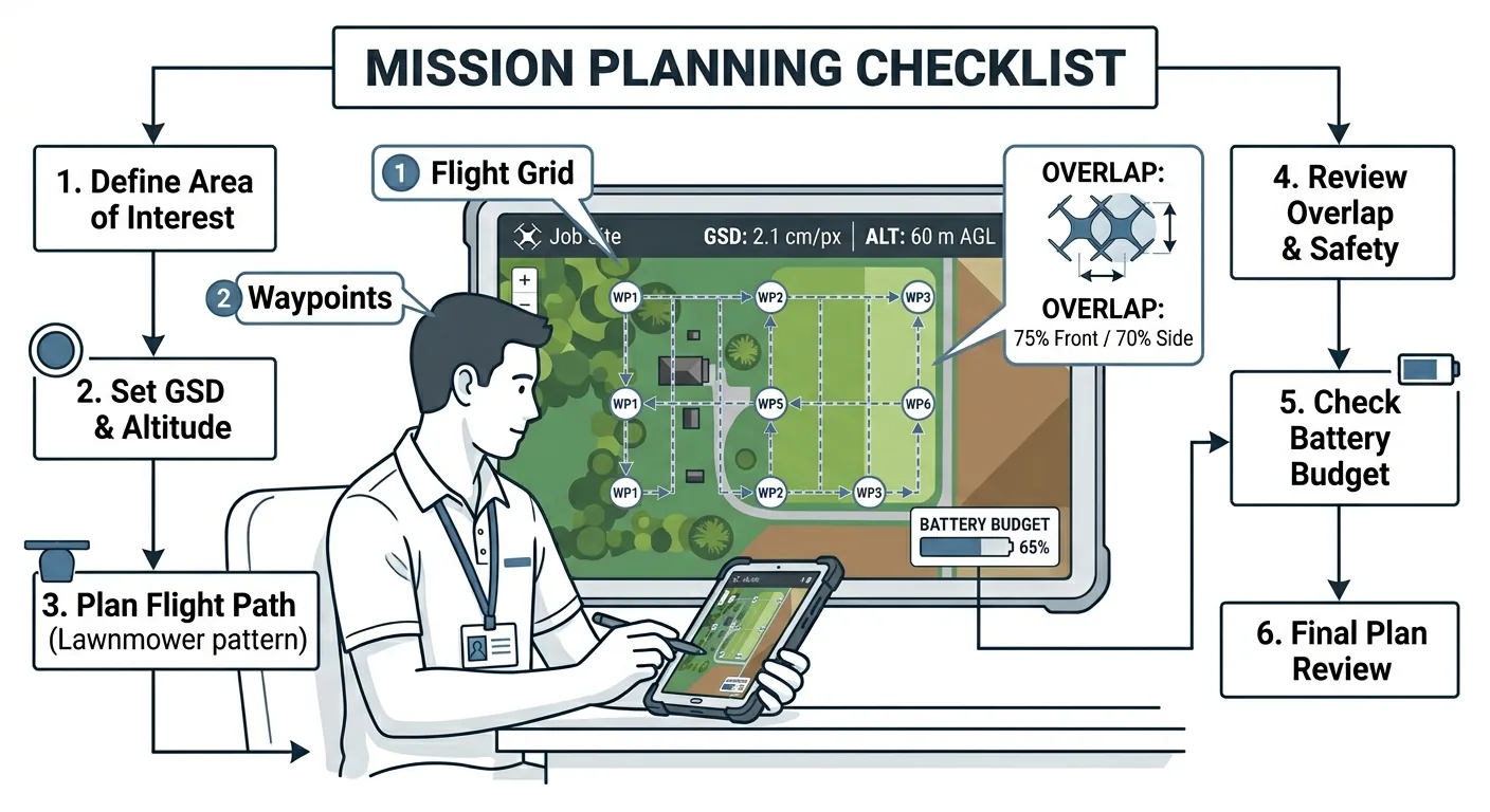
Altitude, GSD, overlap, battery budget — the four parameters that decide whether drone mapping data is usable. Mission planning checklist for surveyors.

LiDAR vs photogrammetry for drone surveys: real accuracy numbers, hardware costs, processing workflows, and a decision framework — when each technology wins, and when it doesn't.

Four positioning tiers for drone surveys: GPS, RTK/PPK, GCPs, and full RTK+GCPs+checkpoints. Match accuracy to the job — not every project needs the top tier.
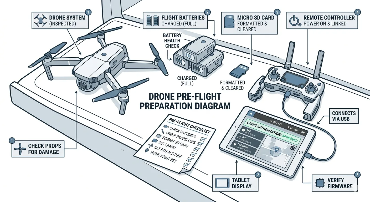
Pre-flight checklist for drone surveys: airspace verification, weather assessment, equipment inspection. Part 1 of the 7-phase drone mapping checklist series.

Six-phase drone mapping checklist from pre-flight to deliverable handoff. Based on aviation protocols — prevents costly reflys and data rejection.

RTK vs PPK for drone surveys: both hit 1-3cm accuracy. RTK corrects in real time, PPK processes post-flight. Failure modes, costs, when to use each.

AeroCartwright: drone mapping education and geospatial tools from a working GIS professional with firefighting, academic, and federal field experience.
Free download: The Complete Drone Mapping Workflow Guide — 30+ pages of field-tested methodology.
Technical content only. Unsubscribe anytime.