


You’re standing at a survey site. The project needs centimeter-level accuracy. Your drone supports both RTK and PPK. The equipment manager asks: which do you want?
The textbook answer is they’re equally accurate, so it shouldn’t matter. Except it does — but not for the reason most people think.
RTK vs PPK: The Short Answer
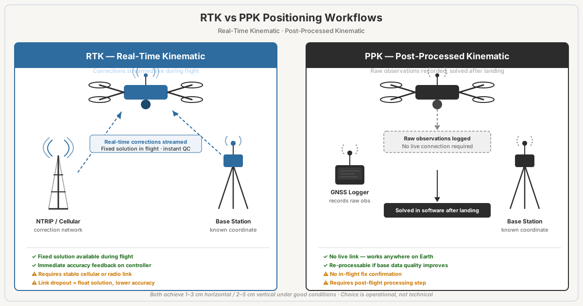
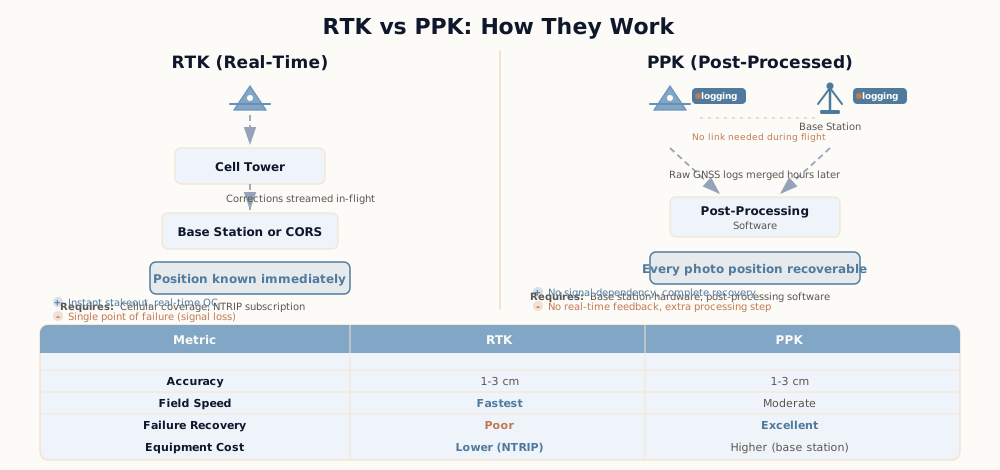
RTK (Real-Time Kinematic) and PPK (Post-Processed Kinematic) solve the same problem with the same math and the same hardware. Both compare the drone’s raw satellite measurements against a base station at a known position to get centimeter-level camera positions. RTK does it during the flight over a live correction link. PPK does it after landing from recorded files.
Accuracy is not the deciding factor. In one peer-reviewed comparison — Arkalı and Atik (2025), ISPRS Archives, flying a DJI Mavic 3E at 70 m, with RTK on one flight and PPK on a second flight of the same site — the two landed within 2 mm of each other horizontally and 4 mm vertically. The difference is when each one fails and what you can do about it. Choose the one that breaks in ways you can handle.
| Your situation | Use | Why |
|---|---|---|
| Reliable cellular or radio link, open sky, results needed the same day | RTK | Geotags are final at landing. No post-processing step. |
| No cell coverage, remote site, or no network subscription | PPK | No live link required. A base logging on site, or a public reference station, is enough. |
| Buildings, trees, or interference that interrupt the link | PPK | Pix4D’s urban test had only 71% of images RTK-fixed; post-processing evened out the errors. |
| DJI enterprise RTK drone, any site | Both | DJI states its enterprise RTK drones always record raw satellite data, so PPK is a free backup for an RTK flight. |
| Nearest base or reference station is more than 60 km away | PPK, or your own base on site | Emlid’s limits for its multi-band receivers are 60 km for RTK and 100 km for PPK; DJI publishes no equivalent figure, so treat these as a guide. |
| Flight shorter than about 10 to 15 minutes | RTK | DJI’s PPK guide recommends a minimum flight duration of 10 minutes in one place and 15 minutes in another. |
| Deliverable carries an accuracy statement, or the vertical matters | Either, plus GCPs and checkpoints | Neither method validates itself. See the GCP section below. |
To put it plainly: fly RTK when the link is good, keep the raw files every time, and fall back to PPK when the fix drops.
RTK: Real-Time Positioning, Real-Time Liability
RTK stands for Real-Time Kinematic. Here’s how it works in the field.
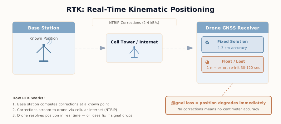
A base station sits at a known location and measures raw GNSS signals. Because its position is known, the errors in those signals can be worked out and passed to the drone. The corrections reach the drone in real time over a radio link, a cellular connection, or NTRIP — the internet protocol that reference-station networks use to stream corrections.
The drone receiver applies that correction stream to its own satellite measurements and resolves the integer ambiguities in the carrier-phase data. Lock onto a “fixed” solution and you get centimeter-level positions: DJI specifies the Mavic 3 Enterprise RTK module and the Matrice 4E at 1 cm + 1 ppm horizontal and 1.5 cm + 1 ppm vertical with an RTK fix (DJI Enterprise spec pages). Lose the correction stream and you drop to “float” — decimeter-level to meter-level positions that look like good data but aren’t.
Getting to a fix is fast on current hardware. Emlid’s documentation lists time to first fix at about 5 seconds for its multi-band ground receivers, against 1 to 2 minutes for older single-band units. The problem isn’t the first fix. It’s every image captured while the drone is trying to get it back.
On DJI platforms such as the Mavic 3 series, the solution type is written into each image’s metadata as RtkFlag. DJI’s Mavic 3M Image Processing Guide defines the values: 50 is a fixed solution (centimeter-level), 32 to 49 is a float solution (decimeter-level to meter-level), 16 is single-point positioning (meter-level), and 0 is no position.
How much does a partial fix cost you? Pix4D published a test with a senseFly eBee Plus at 102 m and 2.5 cm ground sampling distance. Over an open field, 99 percent of camera positions were RTK-fixed and the map came out at around one pixel (2.5 cm) of error in X, Y, and Z with no ground control. Over an urban sports park, buildings, trees, and local Wi-Fi interfered with the link and only 71 percent of positions were fixed. Pix4D found larger errors near the float positions, and in the post-processed result the errors were more even across the site. For what those error numbers mean and how they’re measured, see drone survey accuracy.
This is why auditing solution types after every flight is non-negotiable. Not optional. Non-negotiable.
Multi-constellation receivers — GPS, GLONASS, Galileo, BeiDou all at once — are standard now; DJI lists all four for the Mavic 3 Enterprise and Matrice 4E when RTK is enabled. More satellites in view means better geometry and faster ambiguity resolution. But conditions still matter: poor satellite geometry in a mountain valley, multipath bounce from buildings, weak cellular signal — all of it introduces error and costs you lock.
What breaks RTK? The real-time correction link. Cellular dies mid-flight. The NTRIP service drops. Your antenna sits in the shadow of a building and multipath takes over. The drone loses corrections, the solution drops to float, and you’re busy flying instead of watching the RTK status. Be honest — you’re probably not watching it.
PPK: Post-Processing, Post-Flight Verification
PPK stands for Post-Processed Kinematic. Different operational concept entirely.
The base station logs raw observations. The drone logs raw observations too. Both record satellite data, not processed positions. After you land, you run the two files through post-processing software — Emlid Studio (free), DJI Terra, REDcatch REDtoolbox, or the open-source RTKLIB.
The software solves the whole trajectory after the fact, using the same differencing between base and drone that RTK uses. Because nothing has to arrive in real time, a dropped link can’t hurt it.
No real-time link required. No cellular dependency. You just fly.
One thing most comparisons miss: PPK does not mean a cheaper, non-RTK drone. PPK needs a drone that records raw satellite observations and a precise timestamp for every shutter event. On DJI enterprise aircraft, that is the RTK hardware. DJI’s PPK workflow guide lists the Mavic 3 Enterprise with RTK module, the Matrice 4 series, and the Phantom 4 RTK, and names the two files its REDtoolbox workflow imports: a raw observation file ending in _PPKRAW.bin and a timestamp file ending in _Timestamp.MRK, both saved in the image folder. DJI also states that its enterprise RTK drones always record this data — so an RTK flight that loses its link can still be post-processed.
The tradeoff is time and discipline. DJI’s PPK guide recommends a minimum flight duration of 10 minutes in one place and 15 minutes in another, so there is enough satellite data to process. You need base data that covers the entire flight — from your own receiver, a DJI D-RTK station, or a public reference station such as the NGS CORS network. And before you leave the site, you verify that the base log and the drone’s files actually exist and cover the flight. No exceptions.
That last step? It is the one that gets skipped. A base that stopped logging, a full SD card, a missing timestamp file — none of it shows up until processing, and by then you’ve left the site.
RTK vs PPK accuracy: what published tests show
Vendor specs describe the receiver. Checkpoint tests describe the map. They are different numbers, and the map is usually worse.
| Source | Setup | RTK result | PPK result |
|---|---|---|---|
| DJI spec pages (Mavic 3 Enterprise RTK module, Matrice 4E) | Receiver position with RTK fix | 1 cm + 1 ppm horizontal, 1.5 cm + 1 ppm vertical | Not stated separately |
| Emlid Reach RS3 and RS4 spec (base or rover receiver) | Receiver position | 7 mm + 1 ppm horizontal, 14 mm + 1 ppm vertical | 5 mm + 0.5 ppm horizontal, 10 mm + 1 ppm vertical |
| Arkalı and Atik (2025), ISPRS Archives XLVIII-M-6-2025 | DJI Mavic 3E, 70 m, about 10 hectares, nine checkpoints, direct georeferencing | RMSE 3.7 cm horizontal, 7.5 cm vertical | RMSE 3.5 cm horizontal, 7.1 cm vertical |
| Pix4D field test (blog, 2017, updated 2022) | senseFly eBee Plus, 102 m, 2.5 cm GSD, open field, 99% RTK-fixed, no GCPs | About 2.5 cm in X, Y, and Z; 2.7 cm vertical | Not needed |
| Pix4D urban test (same article) | Same aircraft, urban park, 71% RTK-fixed | Larger errors near float positions | 6.7 cm vertical (4.8 cm with well-distributed GCPs) |
| Famiglietti et al. (2021), Sensors 21(11), 3882 | Emlid Reach M+ on a custom quadcopter, PPK against three different bases, DEM heights compared at seven ground points | Not tested | Height differences of 1 to 35 cm with a Trimble Alloy base, 2 to 30 cm with an Emlid Reach RS2, 5 to 56 cm with a national network station |
Three things stand out.
RTK and PPK are a wash when both work. Arkalı and Atik’s gap is 2 mm horizontal and 4 mm vertical on nine checkpoints. The authors report PPK as the better performer; a difference that small on nine points is not a reason to choose one over the other.
Vertical is the weak axis. Both methods came in above 7 cm vertical in the Mavic 3E test even with a 1.5 cm vertical receiver spec. The receiver is not the map.
The base matters as much as the method. In Famiglietti et al., the same flight processed against three different bases gave height differences at seven ground points of 1 to 35 cm (Trimble Alloy), 2 to 30 cm (Emlid Reach RS2) and 5 to 56 cm (a national network station). The low-cost RS2 base performed in the same range as the Trimble Alloy. The abstract’s headline “RMSE” figures of 1.9 to 5.1 cm are not used here: they equal the smallest single-point error for each base in the paper’s own Table 3, not a root mean square.
Baseline Distance: How Far Can the Base Be?
The baseline is the distance between the base station and the drone. Both RTK and PPK assume the base and the drone see the same atmosphere. The farther apart they are, the less true that is.
That is what the “ppm” in every accuracy spec means: parts per million of baseline length. One ppm is 1 mm of added error per kilometer. Applied to DJI’s published RTK spec of 1 cm + 1 ppm horizontal and 1.5 cm + 1 ppm vertical:
| Baseline | Horizontal (1 cm + 1 ppm) | Vertical (1.5 cm + 1 ppm) |
|---|---|---|
| 1 km (base on site) | 1.1 cm | 1.6 cm |
| 10 km | 2.0 cm | 2.5 cm |
| 30 km | 4.0 cm | 4.5 cm |
| 60 km | 7.0 cm | 7.5 cm |
These figures are arithmetic on the manufacturer’s formula — a best case for the receiver position under good conditions, not a measured map accuracy.
Then there are the maximum baselines a receiver supports. Emlid’s documentation gives them by receiver type:
| Receiver type | Maximum RTK baseline | Maximum PPK baseline |
|---|---|---|
| Multi-band (Reach RS2 in Emlid’s comparison) | 60 km | 100 km |
| Single-band (Reach RS+ in Emlid’s comparison) | 10 km | 30 km |
Emlid’s RTK guide adds that with an NTRIP service the baseline “should generally not exceed 60 km” and that the baseline should be kept as short as possible. A radio link is shorter still: the Reach RS3’s LoRa radio is specified at up to 8 km.
The practical read: PPK tolerates a longer baseline than RTK, which is why it suits large or remote sites. But longer is never better. At 60 km, the distance term alone is six times the fixed part of DJI’s horizontal spec. A base on site beats a reference station two counties away, whichever method you run.
The Failure Modes That Matter
RTK fails like this: You’re flying, signal is good, everything looks fine. Then you drift out of cellular range or the NTRIP stream drops, and a share of your images are tagged with float solutions. The check is simple — read the fix status of every image before you leave. The fix is either a reflight of that section or, if the drone recorded raw data, PPK.
PPK fails like this: You deploy the base, verify it looks good, fly the mission clean. But the base stopped logging early, or the raw files didn’t write completely, or you enter the wrong base coordinates in post-processing. You discover all of this when you sit down to process — and by then you’ve already left the site. No going back.
Both workflows carry the same garbage-in-garbage-out risk: the base position. RTK and PPK measure the drone relative to the base. Put the base on the wrong coordinates and the entire map shifts by the same amount — precise, consistent, and wrong. This is not a rare edge case. A base that simply averages its own position is only good to meters: DJI specifies the D-RTK 3’s uncalibrated single-point accuracy at 1.5 m horizontal and 3.0 m vertical (RMS). Set the base on a known point, tie it to a reference network, or expect an offset of that size in every coordinate. The datum has to match too — see coordinate systems for drone operators.
RTK gives you wrong answers immediately. PPK gives you wrong answers hours later.
This is why pre-departure file verification is critical in PPK workflows. Not nice-to-have. Critical.
Do You Still Need GCPs?
Yes.
I know that’s not what you want to hear. RTK and PPK both correct the camera position to the centimeter. Neither corrects a wrong base coordinate, a datum mismatch, or a camera calibration that drifts during processing. Centimeter precision around the wrong location is still the wrong location.
The published tests say the same thing. In Pix4D’s urban flight, the PPK result came in at 6.7 cm vertical error; the same site flown without RTK and processed with well-distributed ground control points (GCPs) came in at 4.8 cm, and Pix4D’s own conclusion was that neither RTK nor PPK beat well-distributed GCPs there. In its open-field flight the result reversed — RTK at 2.7 cm vertical against 6.6 cm with GCPs. Good conditions, good RTK. Bad conditions, you want control on the ground.
There are two separate jobs here, and they need separate points:
- Ground control points go into the processing and pull the model onto the ground. They matter most for the vertical. The mechanics are covered in why your RTK drone still needs GCPs and the full ground control points guide.
- Checkpoints stay out of the processing and measure the error afterward. They are the only way to know your accuracy rather than assume it. The ASPRS Positional Accuracy Standards, Edition 2, set a minimum of 30 checkpoints for a full accuracy statement. See checkpoints vs control points and how RMSE is calculated.
Same goes for PPK. Post-processing doesn’t validate your accuracy — it refines it. You still need independent checkpoints to know you’re good.
For the broader “which positioning tier do I actually need” decision — before the RTK vs PPK choice even comes up — see the four-tier positioning framework.
Cost Reality Check
The drone costs the same either way. PPK needs the raw satellite log, and on DJI enterprise aircraft that log comes from the RTK hardware. The cost difference is in where the corrections come from.
| Item | Price | Source (checked 2026-10-01) |
|---|---|---|
| Emlid Reach RS2+ base receiver | $2,699 | Emlid store |
| Emlid Reach RS3 base receiver | $2,999 | Emlid store |
| Emlid Reach RS4 base receiver | $3,899 | Emlid store |
| Emlid Caster (stream your own base over NTRIP) | Free | Emlid |
| Emlid Studio (PPK processing) | Free | Emlid |
| RTKLIB (PPK processing) | Free, open source | RTKLIB project |
| Point One Polaris True RTK network corrections | $750 per year per license billed annually ($85 per month billed monthly) | Point One pricing page |
| NYSNet real-time network (New York) | No fee | NYSDOT |
Photogrammetry software is a separate line and identical for both methods: Agisoft Metashape Professional is $3,499 as a perpetual license, and Pix4Dmapper is $3,990 per year on Pix4D’s pricing page. For the full breakdown, see the photogrammetry software comparison.
Field time: RTK through a network has nothing to set up beyond logging in. Your own base has to be set up and positioned for either method.
Office time: RTK skips post-processing when the fix held. PPK adds a step — Pix4D puts it at 10 to 20 minutes.
Here’s the calculus. A paid network at $750 a year (annual billing) or $85 a month ($1,020 a year, monthly billing) is a recurring cost; a $2,999 Reach RS3 costs about four years of annual billing ($2,999 ÷ $750 = 4.0), and then keeps working where there is no cell signal. If your state runs a free network and your sites have coverage, RTK corrections cost nothing and the base is optional. Check what your state offers before you pay for either.
When to Choose RTK
RTK is your method if the correction link is solid at the site and you need geotags that are final at landing. Repeated surveys at the same location with reliable coverage? RTK is simpler. Turnaround is critical and you want minimal post-processing? RTK again.
Urban construction sites with good cellular coverage are the classic RTK job: same site several times a month, and the client wants updates fast. Just check the fix status on every image — built-up sites are also where links drop.
When to Choose PPK
Pick PPK if cellular is poor, expensive, or unavailable — remote sites, places where infrastructure doesn’t reach. If you want a result you can reprocess and audit (the raw data sits there, and post-processing is repeatable), PPK gives that to you. If the nearest reference station is far away, PPK’s longer baseline limit gives you more room.
Remote archaeological sites? One-off environmental surveys? Anywhere the link is spotty? PPK wins.
When to Use Both
This is the answer most comparisons skip. On a DJI enterprise RTK drone you don’t have to choose before takeoff. Fly with RTK on. Keep the _PPKRAW.bin and _Timestamp.MRK files with the images. Log your base, or note which reference station covers the flight.
If every image comes back with RtkFlag 50, you’re done. If some come back float, post-process the same flight instead of reflying it. Emlid Studio is built for exactly that case — updating images from an RTK drone after the real-time link was lost.
The cost of this habit is some storage space. The cost of skipping it is a second trip to the site.
What Actually Matters
The choice comes down to logistics and risk tolerance. Both methods reach the same accuracy under good conditions. Both require checkpoint validation — that’s how you know you’re actually good. Both fail. Just in different ways, at different times.
RTK fails in the field, and the per-image fix status tells you so before you leave. PPK fails in the files, and you can catch it before leaving site if you verify them.
RTK requires a real-time correction link that can disappear. PPK requires discipline in on-site setup and pre-departure verification.
Good coverage, repeated flights at the same site — RTK wins. Remote site, long baseline, unreliable link — PPK wins. Neither condition clearly applies? Fly RTK and keep the PPK files.
That’s the real difference: not accuracy, but how fast you get confidence in it.
FAQ
RTK vs PPK: which is better for drone mapping?
Neither is more accurate by design. In a 2025 Mavic 3E test by Arkalı and Atik, checkpoint RMSE was 3.7 cm horizontal and 7.5 cm vertical with RTK, and 3.5 cm and 7.1 cm with PPK. Use RTK when the correction link is reliable and you need final geotags at landing. Use PPK when the link is unreliable or absent. On DJI enterprise drones, fly RTK and keep the PPK files as a backup.
What is the difference between RTK and PPK?
Timing. RTK streams base-station corrections to the drone during the flight, so every image is geotagged with a corrected position as it is captured. PPK records raw satellite observations on the drone and at the base, then solves the camera positions after landing. RTK needs a live radio or internet link for the whole flight. PPK does not.
Do I need GCPs if I use RTK or PPK?
For any deliverable with a stated accuracy, yes: you need independent checkpoints at minimum, and ground control when the vertical matters. RTK and PPK correct the camera position, not the base coordinates, the datum, or the camera calibration. In Pix4D’s urban test, the PPK result had 6.7 cm vertical error against 4.8 cm with well-distributed GCPs.
What happens if the RTK signal drops during a flight?
The solution falls from fixed to float or single, and those images carry decimeter-level to meter-level positions. DJI records the status per image in the RtkFlag metadata field: 50 is fixed, 32 to 49 is float, 16 is single. DJI enterprise RTK drones keep recording raw satellite data, so the flight can be reprocessed with PPK instead of reflown.
How far can the base station be from the drone?
Emlid lists a maximum baseline of 60 km for RTK and 100 km for PPK on multi-band receivers, and 10 km and 30 km on single-band receivers. Accuracy degrades with distance: DJI specifies 1 cm + 1 ppm horizontal, which adds 1 cm of error for every 10 km of baseline. Keep the baseline as short as you can.
Which costs more, RTK or PPK?
The drone is the same either way, because PPK needs the raw satellite log that an RTK-capable drone records. The difference is corrections. A paid network is a recurring cost: Point One lists Polaris True RTK at $750 per year per license on annual billing, or $85 a month billed monthly. Your own base is a one-time purchase: an Emlid Reach RS3 is $2,999, and Emlid Studio for PPK processing is free. Some state networks, such as New York’s NYSNet, charge nothing.
Can PPK be more accurate than RTK?
Slightly, on paper. Emlid specifies its Reach RS3 at 5 mm + 0.5 ppm horizontal in PPK against 7 mm + 1 ppm in RTK. In practice the published gap is a few millimeters: 3.5 cm against 3.7 cm horizontal RMSE in Arkalı and Atik (2025), measured on nine checkpoints. PPK’s real advantage is recovering flights where the RTK link dropped.
Is RTK or PPK easier to learn?
RTK. DJI’s own PPK guide describes RTK as typically easier to use than PPK, requiring less skill to set up and operate. The same guide rates RTK as less accurate than PPK when the link is interrupted. PPK adds a base log, a timestamp file, and a processing step. Both still require you to check the result: fix status per image for RTK, and complete base and drone logs before leaving the site for PPK.
Sources
- Arkalı and Atik (2025), ISPRS Archives XLVIII-M-6-2025: RTK and PPK comparison with a DJI Mavic 3E
- Famiglietti et al. (2021), Sensors 21(11), 3882: PPK with low-cost receivers against three bases
- Pix4D: RTK, PPK and GCP comparison field test
- DJI: PPK workflow guide, Mavic 3 Enterprise specs, D-RTK 3 specs
- Emlid: single-band vs multi-band baseline limits, Emlid Studio