


Picture a surveyor on a panel deposition. The project is a year old, the site has been built on, and a contractor is suing over a grading discrepancy. Opposing counsel slides a PDF across the table — the drone deliverable the design engineer relied on — and asks two questions.
“Which standard does the RMSE on page three reference?”
“How many independent checkpoints were used?”
The deliverable lists a single number — 4.2 cm — under “accuracy.” No standard. No checkpoint count. No cover sheet. The witness explains it came from the Pix4D quality report. Counsel asks whether that was GCP residual or independent checkpoint validation. The witness is not sure.
That deliverable is no longer evidence of an accuracy claim. It is evidence the witness did not make one. The work was probably fine. The reporting wasn’t. A defensible drone survey accuracy claim is built before the first flight, not reconstructed after the subpoena lands.
What Changed in 2023–2024: ASPRS Edition 2 and the Fourth Circuit Ruling
The American Society for Photogrammetry and Remote Sensing (ASPRS) published Positional Accuracy Standards Edition 2, Version 1 in August 2023, and its Board adopted Edition 2, Version 2 on June 24, 2024, after a public review that closed April 26, 2024 (ASPRS announcement). Edition 2 replaced Edition 1 (2014). Root Mean Square Error (RMSE) is now the only accuracy measure: Edition 2’s summary of changes says it “eliminated references to the 95% confidence level as an accuracy measure.” The minimum checkpoint count rose from 20 to 30 (capped at 120 for very large projects), and the accuracy statement is now a fill-in-the-blank template. A report that cites “ASPRS standards” without naming the edition is ambiguous, because the two editions use different checkpoint minimums and reporting forms.
The second change is legal. On May 20, 2024, the Fourth Circuit Court of Appeals decided 360 Virtual Drone Services LLC v. Ritter, holding that North Carolina’s surveyor-licensing act could be applied to a drone operator’s aerial mapping without violating the First Amendment. The Supreme Court denied review on April 20, 2026 (docket No. 24-279). “Is the deliverable accurate?” is no longer the only question that matters. “Is this work licensed surveying in this state?” matters just as much.
What “Centimeter Accuracy” Actually Means
In marketing
A drone manufacturer’s spec sheet that claims “1 cm Real-Time Kinematic (RTK) accuracy” describes the GNSS receiver’s antenna phase center position under ideal conditions: open sky, short baseline, stable atmosphere. That is a sensor specification, not a deliverable accuracy claim. It excludes the lever arm between GNSS antenna and camera optical center, the timing latency between GNSS epoch and shutter trigger, the geoid model used for orthometric conversion, and any bundle-adjustment doming. ASPRS’s own UAS addendum (Addendum V of Edition 2, Version 2) says that, set up properly, airborne RTK “may allow” “typical accuracies in the 5–10 cm range,” and well-run PPK “frequently” reaches 1–2 cm horizontal and 2–4 cm vertical — and it adds that “it is still highly recommended that GCPs be surveyed.” The spec sheet is true. A deliverable claim derived from it is not.
In court
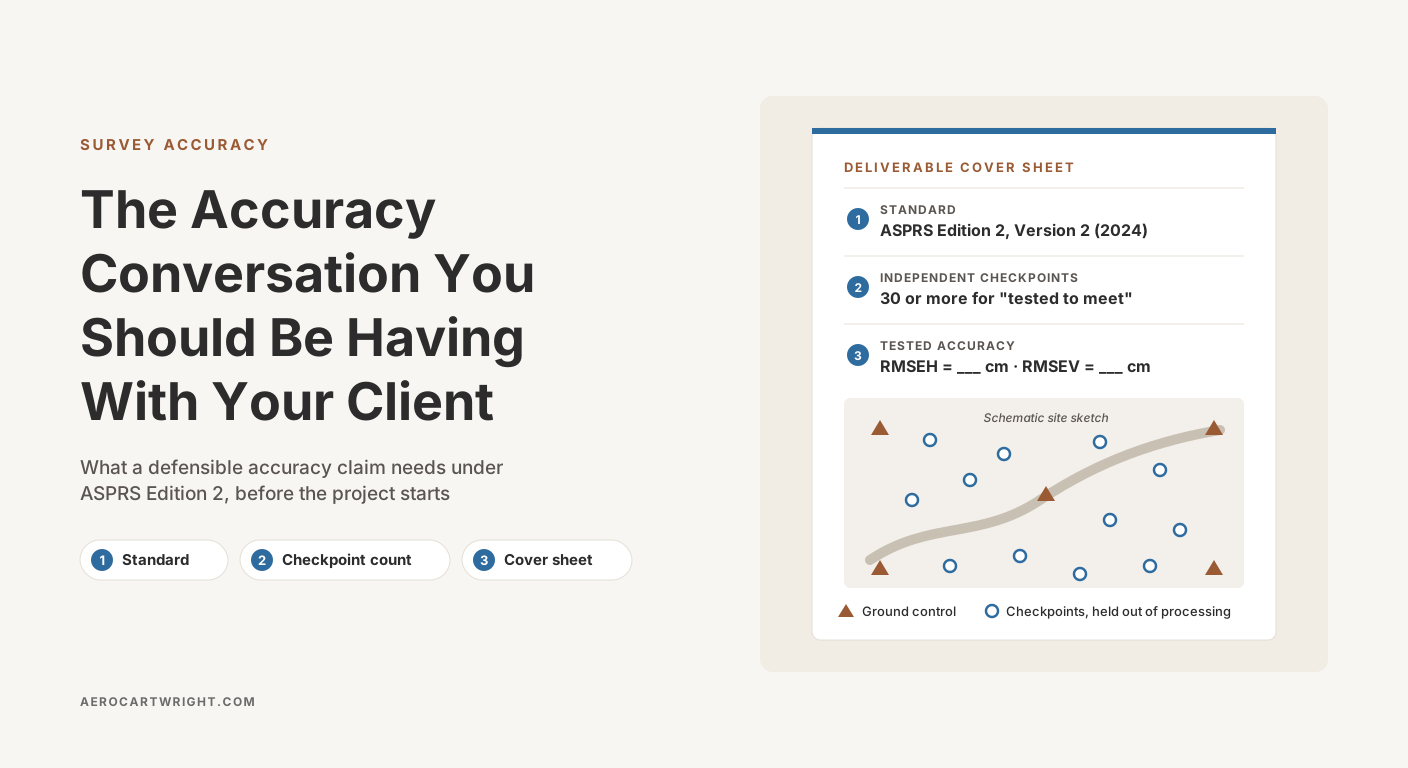
An accuracy claim has three parts: the standard, the checkpoint count, and the cover sheet. Drop any one and it collapses. “Centimeter accuracy” without a cited standard tells counsel the witness did not use one. A number without a checkpoint count means no independent validation happened. A deliverable without a cover sheet means nothing was documented at the time of delivery. The bar for a defensible accuracy statement is not technical. It is documentary.
The underlying math (what RMSE measures, why vertical is usually worse, how to convert between RMSE, CE90/LE90, and National Standard for Spatial Data Accuracy (NSSDA) 95% statements) is covered in RMSE Explained for Drone Surveyors. The conversation here is about the reporting wrapper around it.
ASPRS Edition 2 and NSSDA: Which Standard Applies to Your Deliverable
ASPRS Positional Accuracy Standards Edition 2 (2023; Version 2, 2024)
Edition 2 is ASPRS’s current standard for reporting the positional accuracy of orthoimagery, planimetric data and elevation data, which covers drone, lidar and photogrammetric deliverables. Key changes from Edition 1 (2014), all from Edition 2’s own summary of changes, Section 7 and Appendix C:
- RMSE is the only accuracy measure. Edition 2 dropped the 95% confidence level as an accuracy measure. If a contract still asks for a 95% figure, NSSDA’s multipliers (1.7308 horizontal, 1.9600 vertical, below) are where it comes from, but it is no longer part of the ASPRS statement.
- Components renamed. Horizontal accuracy is reported as RMSEH and vertical as RMSEV, replacing Edition 1’s RMSEx/RMSEy and RMSEz. As USGS puts it, “RMSEz has been replaced with RMSEV” and “RMSEx and RMSEy have been combined into RMSEH.” RMSE3D is new: a combined three-dimensional accuracy for 3D models and digital twins.
- Minimum 30 independent checkpoints, maximum 120. Edition 1’s minimum was 20. Edition 2 raised it to 30, citing the central limit theorem, and its Appendix C recommends 30 for any project up to 1,000 square kilometers, which covers any drone site. If you test with fewer, Edition 2 gives a separate statement that discloses the count (shown in Block 7 below).
- Control and checkpoint survey accuracy relaxed. Edition 1 asked for ground control 4× and checkpoints 3× more accurate than the product. Edition 2 asks for 2× for both.
- Checkpoint survey error now counts. Because of that relaxation, Edition 2 combines the surveyor’s own checkpoint error with the product’s fit to the checkpoints: RMSEH = √(RMSEH1² + RMSEH2²), where RMSEH1 is the fit and RMSEH2 is the survey error. Vertical works the same way.
- Bias check. Edition 2 recommends a mean error below 25% of the target RMSE. A larger mean “should be investigated to diagnose the cause,” and the findings go in the metadata.
- Standard accuracy statements. “Tested to meet” (30 or more independent checkpoints), a reduced-checkpoint version that states how few were used, and “produced to meet” (no independent test, meant for producers who can show repeatable results). All three are statements Edition 2 provides. ASPRS files the reduced-checkpoint one under “Accuracy Testing Does Not Meet ASPRS Standard Requirements” and offers it where 30 checkpoints are not feasible (Appendix C.3). Only the first is fully compliant, and only the first two report a measured accuracy. Inventing your own wording is not one of the options.
Version 2 also added Addendum V — Best Practices and Guidelines for Mapping with Unmanned Aerial Systems — which describes direct georeferencing and RTK/PPK workflows and defines checkpoints as “an independent collection of surveyed ground control points that validate the reported accuracy … and have been excluded from the processing in the aerial triangulation.”
NSSDA (FGDC-STD-007.3-1998)
NSSDA is the federal standard. Its applicability section says to “use the NSSDA to evaluate and report the positional accuracy of maps and geospatial data produced, revised, or disseminated by or for the Federal Government” (NSSDA §3.1.3). NSSDA expresses accuracy at 95% confidence: 1.7308 × RMSEr for horizontal (which assumes the X and Y errors are about equal) and 1.9600 × RMSEz for vertical. The reporting statement: “Tested ____ (meters, feet) horizontal accuracy at 95% confidence level.”
A mistake to watch for: using 1.96 for horizontal. That value is the 95% factor for a one-dimensional normal error and applies only to the vertical component. Horizontal uses 1.7308 because the error is two-dimensional (circular). A report that uses 1.96 horizontally overstates the figure by 1.96 ÷ 1.7308 = 1.13, about 13%. NSSDA also “does not define threshold accuracy values” — what counts as accurate enough is the contract’s job.
Which standard to cite
Read the contract first: the standard it names governs. Federal work: NSSDA, unless the agency’s own specification says otherwise — USGS 3DEP, for one, adopted ASPRS Edition 2, Version 2 in its Lidar Base Specification 2024 rev. A. State DOT work: check which edition the spec names, because a spec written before Edition 2’s August 2023 release can only cite Edition 1. Private work with no named standard: cite ASPRS Edition 2, Version 2 by name, and add NSSDA 95% figures if the client asks. Both standards can sit on the same deliverable without conflict. The problem is not picking one. The problem is omitting both.
The Deliverable Cover Sheet (The Defensibility Artifact)
The cover sheet is the highest leverage-per-effort document an operator can add to a deliverable. One or two pages, and a numeric accuracy claim becomes a defensible one. A cover sheet with the wrong geoid is more defensible than one with no geoid named. The wrong-geoid case is a correctable error documented at delivery. The missing-geoid case is a documentation failure that cannot be fixed retroactively.
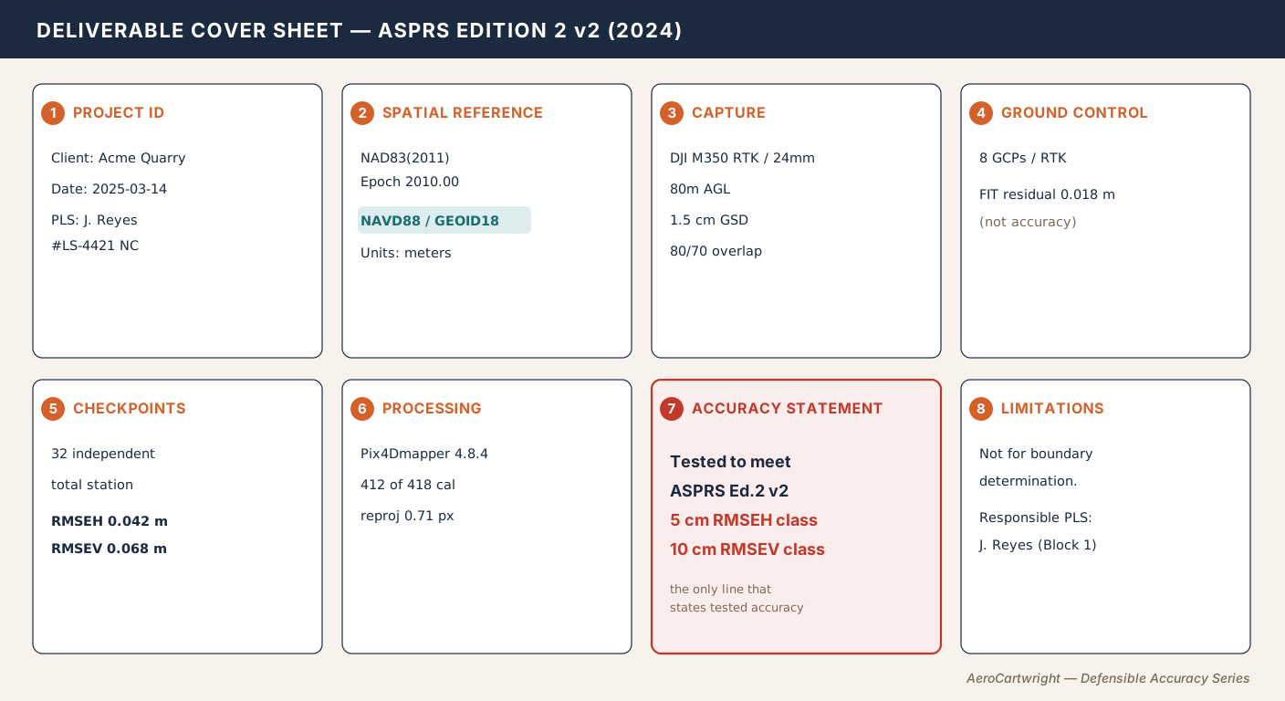
The schema below is our own compilation, built around Edition 2’s Section 7 reporting requirements. It is not an official ASPRS form.
| Block | Required fields |
|---|---|
| 1. Project ID | Project, client, site, capture and report dates, pilot + Part 107 number, Professional Land Surveyor (PLS) of record (name + license + state, if applicable), processing operator |
| 2. Spatial Reference | Horizontal datum (e.g., NAD83(2011) Epoch 2010.00), horizontal CRS, vertical datum (e.g., NAVD88), geoid model (e.g., GEOID18 in the conterminous US — REQUIRED for orthometric heights), units (US Survey Feet / International Feet / Meters) |
| 3. Capture | Airframe + payload, focal length, pixel size, AGL altitude, Ground Sample Distance (GSD), overlap (front/side), flight pattern, RTK / Post-Processed Kinematic (PPK) status + base station name and distance |
| 4. Ground Control | Ground Control Point (GCP) count, placement, target type, survey method, per-axis fit residuals labeled “FIT, not accuracy” |
| 5. Checkpoints | Count (if below the ASPRS minimum of 30, say so and use the reduced-checkpoint statement in Block 7), placement, survey method + survey accuracy (RMSEH2 / RMSEV2, which Edition 2 folds into the reported accuracy), per-checkpoint table (ID, surveyed XYZ, model XYZ, dX/dY/dZ), summary stats (max, min, mean/bias, median, std dev, RMSEX, RMSEY, RMSEH, RMSEV), bias flag if the mean error exceeds 25% of the target RMSE |
| 6. Processing | Software + version, image count, calibrated image count, mean reprojection error (px), camera self-calibration delta (%) |
| 7. Accuracy Statement | Standard cited (ASPRS Edition 2 v2 2024 / NSSDA 1998 / both), filled-in reporting statement: “tested to meet,” reduced-checkpoint, or “produced to meet” |
| 8. Limitations | Intended-use statement, boundary-determination prohibition, who is professionally responsible for the work. A limitation describes the product; it does not change whether producing it is licensed surveying in your state (see the state section below) |
The order matters. A reviewer reads top down: project identity, what space the data lives in, how it was captured, what constrained it, how it was tested, what produced it, what is claimed, what the deliverable cannot be used for.
Block 7 is the public-facing claim. Edition 2 Version 2 provides exact language:
“This data set was tested to meet ASPRS Positional Accuracy Standards for Digital Geospatial Data, Edition 2, Version 2 (2024) for a __(cm) RMSEH Horizontal Positional Accuracy Class. The tested horizontal positional accuracy was found to be RMSEH = __(cm)”.
The vertical statement is structured the same way with RMSEV. If you tested with fewer than 30 checkpoints, Edition 2 gives a different statement, filed under “Accuracy Testing Does Not Meet ASPRS Standard Requirements,” and it is the one to use:
“This data set was tested as required by ASPRS Positional Accuracy Standards for Digital Geospatial Data, Edition 2, Version 2 (2024). Although the Standards call for a minimum of thirty (30) checkpoints, this test was performed using ONLY __ checkpoints. This data set was produced to meet a ___(cm) RMSEH Horizontal Positional Accuracy Class. The tested horizontal positional accuracy was found to be RMSEH = ___(cm) using the reduced number of checkpoints.”
If no independent checkpoints were surveyed at all, the “produced to meet” statement is the honest alternative. It cannot be called a tested accuracy.
For the mechanics of pulling Blocks 3–6 from a real quality report (which Pix4D fields map to which cover-sheet cell, where Metashape hides the camera self-calibration delta, how WebODM handles checkpoints), see Reading a Drone Mapping Quality Report.
The Conversation Before the Project Starts
RFP language to push back on
Three phrases should trigger a clarifying conversation before you quote.
- “Survey-grade.” Refuse the term. Neither ASPRS Edition 2 nor NSSDA defines a “survey-grade” accuracy class, so it means whatever the writer wants. Ask for a stated RMSE class: “5 cm RMSEH per ASPRS Edition 2.” Survey-grade is a marketing word, not a spec.
- “RTK accuracy.” RTK is a positioning method, not an accuracy claim. What an RTK deliverable actually achieves depends on flight geometry, ground control, the geoid and datum chain, and processing, and only checkpoints show which way it went. Restate as “we will fly RTK; accuracy will be reported against independent checkpoints.”
- “Centimeter accuracy.” Covers 1 cm to 9.9 cm. Tenfold range. Require a checkpoint count, an axis, and a standard.
Scope language to insist on
The scope of work should state the RMSE class (per a named standard), checkpoint count and placement plan, datum, CRS, geoid model, intended-use clause, and — where the work falls within your state’s surveying statute — the licensed surveyor responsible for it. An intended-use clause limits how the client may rely on the product; it does not take work outside a statute that covers it (see the state section below). Each item maps to a cover-sheet block. Each is easier to negotiate before flying than after delivery.
Questions to ask the client
Four questions, asked before the quote, head off most of the misunderstandings behind accuracy disputes:
- What is the deliverable used for — engineering design, volume tracking, legal, public record?
- Is a licensed surveyor reviewing or sealing the output?
- Is it being submitted to a regulator, court, or insurer?
- What contour interval, volume tolerance, or accuracy spec must it meet downstream?
If the client can’t answer question 4, get the spec from their engineer before flying. Quoting against an unstated spec is how operators end up shipping deliverables that are technically accurate and wrong for the use case at the same time.
For the deeper conversation on when RTK is enough and when GCPs are still required, see Why Your RTK Drone Still Needs GCPs.
Where Accuracy Claims Go Wrong
Six failure modes come up again and again.
- GCP RMSE reported as “the accuracy.” GCP RMSE is the model fitting itself. Checkpoint RMSE is the model meeting the ground.
- Zero checkpoints. Without independent validation there is no tested accuracy. The most you can say is “produced to meet,” which Edition 2 reserves for producers who can show repeatable results.
- Wrong or missing geoid. In the conterminous US, Puerto Rico and the US Virgin Islands, GEOID18 replaced GEOID12B; Alaska, Hawaii, Guam and the Northern Mariana Islands still use GEOID12B (NGS GEOID18). An NGS comparison map of GEOID18 (beta) minus GEOID12B shows much of CONUS within a few centimeters but local differences of more than 10 cm, with a legend running from −32 to +23 cm (Roman and Ahlgren, NGS, FIG Working Week 2019, slide 13). Apply no geoid at all and ellipsoid heights get labeled as elevations, off by the full geoid height: NGS’s GEOID18 service returns about −17.1 m at Denver and −31.9 m at New York City.
- Datum confusion. NAD83(2011) labeled as WGS84, or US Survey Feet conflated with International Feet.
- Doming undisclosed. Nadir-only flights can produce a dome-shaped vertical error pattern that checkpoints clustered near GCPs will not detect.
- Auto base plane on uneven ground. Stockpile software commonly fits a plane through points on the pile boundary; if the boundary sits on a slope or uneven ground, that plane misses the true base and the volume error follows it.
Two examples anchor the failure modes.
Example 1: the North Carolina case (documented in the court record). According to the Fourth Circuit’s opinion, Michael Jones’s company, 360 Virtual Drone Services LLC, advertised orthomosaic maps that construction companies could use for “volumetrics for gravel/dirt/rock.” In a December 2018 letter, the North Carolina Board of Examiners for Engineers and Surveyors told him it was investigating whether he was practicing land surveying without a license. Jones replied in January 2019 that he had added a disclaimer to his website. The Board wrote again in June 2019 that, in its view, he was violating the Act. He stopped developing the mapping business and sued in 2021. On May 20, 2024, the Fourth Circuit affirmed judgment for the Board, holding that the Act survives intermediate scrutiny as applied (102 F.4th 263). The Supreme Court denied certiorari on April 20, 2026 and denied rehearing on June 15, 2026 (docket No. 24-279). Two details matter for this article. The disclaimer did not end the Board’s inquiry. And the Board later disavowed any intent to initiate enforcement proceedings over map images and marketing photos “without measurable information.” The measurable data was the issue.
Example 2: GCP-as-accuracy (hypothetical). Eight RTK-measured GCPs, all entered into bundle adjustment, GCP RMSE of 0.6 inches in the Pix4D report. The cover email describes the deliverable as “survey-grade.” Two weeks later a total-station grade check finds four-inch vertical errors across the site. The drone report was answering the wrong question. That 0.6-inch GCP RMSE measured how well the model fit the eight points it was given. No checkpoint was held back, so no real-world accuracy claim was possible. The cover email was the liability, not the photogrammetry.
For the diagnostic side of these failures, see Checkpoints vs Control Points and Diagnosing Vertical Bias in Drone Maps.
State Surveyor Boards — Where You Operate Matters
State boards regulate the activity, not the numbers, and each state’s statute decides what counts as surveying. Five examples, quoted from the statutes themselves. This is general information, not legal advice; for the wider state-by-state picture, see Drone Mapping Without a Surveyor License, and before relying on any of it, ask your state board or a licensed attorney.
- North Carolina. G.S. 89C-3(7) covers mapping and measurement work “whether the gathering of information … is accomplished by conventional ground measurements, by aerial photography, by global positioning via satellites,” and includes “[d]etermining the configuration or contour of the earth’s surface … by measuring lines and angles and applying the principles of mathematics or photogrammetry.” Ritter is the federal appellate decision upholding the Board’s application of this statute to a drone operator.
- California. Bus. & Prof. Code § 8726(a)(2) covers anyone who “[d]etermines the configuration or contour of the earth’s surface, or the position of fixed objects above, on, or below the surface of the earth by applying the principles of mathematics or photogrammetry.” On its face, that clause stands on its own; it does not depend on boundary work.
- Florida. Fla. Stat. § 472.005 lists “photogrammetric control” within the practice of surveying and mapping, and defines a photogrammetrist as “any person who engages in the practice of surveying and mapping using aerial or terrestrial photography or other sources of images.”
- Arizona. A.R.S. § 32-101(22)(d) defines land surveying practice to include measuring features “for the purpose of determining or establishing their location, size, shape, topography, grades, contours or water surface and depths,” and preparing “maps depicting these features.”
- Texas. Narrower on its face. Tex. Occ. Code § 1071.002(6) does reach measuring “elevations, natural features, and existing man-made works” to “determine areas and volumes,” but only for locating real property boundaries, platting and laying out land, or preparing maps, plats and records “that represent those surveys” (§ 1071.002(6)(A)). It does not mention photogrammetry. We found no documented drone-specific enforcement action by the Texas Board of Professional Engineers and Land Surveyors. That is a gray zone, not a green light.
Two practical points follow. First, wording: the court record in Jones’s case centers on the mapping services his website advertised, and calling your work “surveys” or “survey-grade” invites the same scrutiny. Second, disclaimers: a disclaimer or a “photogrammetric product” label describes the deliverable, but it does not change what the statute covers. Jones added one, and the Board still told him he was in violation. Where your state’s statute covers what you deliver, the answer is a licensed surveyor who is responsible for the work, or deliverables that stay outside the definition, such as visual documentation and inspection imagery without measurable data. When in doubt, ask the board in writing.
Volumetrics — The Highest-Stakes Conversation
Stockpile volume is one of the highest-stakes deliverables in commercial drone work, because volume converts directly to invoice dollars. The arithmetic is short: a 2% error on a 50,000 cubic yard pile is 0.02 × 50,000 = 1,000 cubic yards. Multiply by the material’s price per yard to see what is in dispute; at a hypothetical $25 per yard, that is 1,000 × $25 = $25,000 from one pile. The pre-project conversation has to nail down base-plane definition, capture cadence, methodology lock, and signed acceptance of the accuracy class. Before the first flight, not after the first report.
A Pre-Project Checklist
Before the first flight, get answers in writing to all of the following:
- What is the deliverable used for? (engineering design / volume tracking / legal documentation / public record / internal monitoring)
- Is a licensed surveyor reviewing or sealing the output?
- Is the deliverable being submitted to a regulator, court, or insurer?
- What contour interval, volume tolerance, or accuracy specification must it meet?
- Which standard governs the report — ASPRS Edition 2, NSSDA, or a state DOT spec cited by name?
- What datum, CRS, and geoid model are required?
- What number and placement of checkpoints will be performed?
- What delivery format is expected — CAD, GIS, PDF with cover sheet, or all three?
- Does the work fall within your state’s surveying statute, and if so, which licensed surveyor is responsible for it?
- Who owns the liability for boundary or design decisions made from the deliverable?
The pre-project conversation costs nothing. The deposition costs everything.
What to Tell the Client When They Ask “Is This Accurate?”
There is a defensible answer and an indefensible one, and neither takes more than a few lines.
Defensible: “Checkpoint validation per ASPRS Edition 2, Version 2 shows RMSEH = 4.2 cm and RMSEV = 6.8 cm across 32 independent checkpoints distributed across the site. That meets the 5 cm RMSEH and 10 cm RMSEV classes your engineer specified.”
Defensible, with fewer checkpoints: “We tested with only 12 independent checkpoints, fewer than the 30 that ASPRS Edition 2 calls for, so this test does not fully meet the Edition 2 requirement and the classes are stated as ‘produced to meet.’ The data was produced to meet the 5 cm RMSEH and 10 cm RMSEV classes; with that reduced set of checkpoints, the tested values were RMSEH = 4.2 cm and RMSEV = 6.8 cm.”
Indefensible: “We flew RTK so it’s survey-grade.”
The defensible versions cite the standard, give a count (and disclose it when it falls short of 30), separate horizontal from vertical, and reference the spec they were tested against. The indefensible version names a positioning method and a marketing word. Both fit in a single email. One holds up in a deposition. The other is the deposition.
If your accuracy statement doesn’t cite a standard, you don’t have an accuracy statement. You have a number. ASPRS Edition 2 didn’t make accuracy harder. It made vague accuracy claims indefensible.
AeroCartwright reviews drone survey deliverables for ASPRS Edition 2 and NSSDA compliance, builds cover sheet templates around the Edition 2 reporting statements, and helps surveyors integrate drone-derived products into PLS-sealed workflows. Putting together a defensible deliverable package, or trying to clean up one you already shipped? Start that conversation here.
References
Research and standards cited in this article.
- ASPRS. (2024). ASPRS positional accuracy standards for digital geospatial data (Edition 2, Version 2.0). American Society for Photogrammetry and Remote Sensing. doi:10.14358/ASPRS.PAS.2024
- Federal Geographic Data Committee. (1998). Geospatial positioning accuracy standards, Part 3: National standard for spatial data accuracy (FGDC-STD-007.3-1998). Federal Geographic Data Committee. link
- Roman, D., & Ahlgren, K. (2019). GEOID18: Last U.S. hybrid geoid prior to NAPGD2022 [Conference presentation]. FIG Working Week 2019, Hanoi, Vietnam. link
- U.S. Geological Survey. (2024). Lidar base specification 2024 rev. A: Adopt updated accuracy standards. U.S. Geological Survey National Geospatial Program. link