
The FAA has issued civil penalties ranging from $1,771 to $36,770 per operator in recent enforcement sweeps — with statutory authority to fine individuals up to $75,000 per violation. The most common triggers: airspace incursions and unlicensed commercial operations. Between October 2022 and early 2025, the FAA proposed over $341,000 in civil penalties against drone operators across dozens of cases — and enforcement is accelerating. One airspace violation, one unchecked NOTAM, one skipped authorization — and the resulting fine wipes out an entire quarter’s profit. Your insurance won’t cover it. Regulatory penalties rarely are.
That’s how risk works in drone mapping. Drones mitigate risk — they replace dangerous manual inspections, reduce crew exposure on active job sites, keep people off unstable slopes. But drone operations introduce their own risks, and they’re not abstract. They’re financial, legal, and physical.
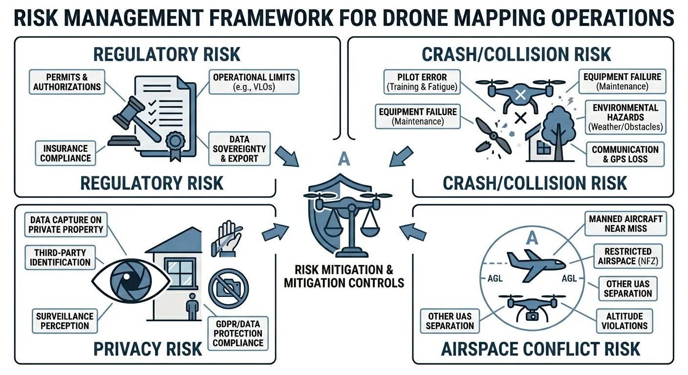
This article covers the four primary risk categories: regulatory violations, drone crashes, airspace conflicts, and privacy exposure. Every one of them presents a financial or legal threat. Some present a safety threat to the public.
This article is written from a U.S. perspective. This is not legal advice — when in doubt, contact a specialty lawyer.

Think in Terms of Probability and Impact
Before every flight, run two questions through your head: how likely is this to happen, and how bad is it if it does?
That’s the risk matrix. Simple concept — but most operators skip it because they’ve flown the same mission profile fifty times without incident. The fifty-first time is the one where a $14,000 drone meets a 200-foot cell tower you didn’t see on the sectional.
Here’s how the four risk categories break down:
| Risk Category | Probability | Impact | Preventability |
|---|---|---|---|
| Regulatory Violation | Low (if you’re disciplined) | High — fines from $1,100 to $75,000 per violation, certificate suspension | 100% preventable |
| Drone Crash | Moderate — most operators will have at least one | High — $3,000 to $30,000+ equipment loss, potential third-party liability | Mostly preventable |
| Airspace Conflict | Low per flight, but cumulative over a career | Catastrophic — mid-air collision with manned aircraft | Manageable with active monitoring |
| Privacy Violation | Moderate — depends on operating environment | Variable — lawsuit, reputational damage, loss of client trust | Highly preventable with planning |
| Remote ID Non-Compliance | Low (if you check your gear) | High — civil penalties, certificate suspension or revocation | 100% preventable |
| GPS Spoofing / Interference | Low in domestic ops, rising near borders | Moderate to High — corrupted survey data, false geotags, bad deliverables | Mitigable with multi-GNSS, RTK/PPK, GCP validation |
An event that’s both high-probability and high-impact is unacceptable. You either eliminate the risk or you don’t fly. An unlikely event with low impact is something you accept and move on. Everything in between requires a conscious decision — not a shrug.
Regulatory Violations
Regulatory violations are 100% avoidable. Full stop. No professional pilot should accept this risk.
Once you obtain your Part 107 Certificate, you’re in the same pilot database as the captain flying a 737 out of DFW. The FAA treats enforcement the same way. They don’t care that your aircraft weighs 5 pounds instead of 175,000.
Flying Without a License. The United States requires all commercial drone operators to hold a Part 107 Remote Pilot Certificate. If you’re making money with your drone and don’t have Part 107, you’re flying without a license. The FAA has proposed fines of $16,000 or more for unlicensed commercial operations — and they actively monitor social media and job postings to find violators.
Flying in Restricted Areas. This covers both airspace and ground restrictions. The FAA controls the airspace above you — restrictions vary by location, altitude, and time. What catches people off guard: federal, state, and local governments can also restrict drone takeoff and landing within their jurisdiction. National parks, military installations, critical infrastructure — all off-limits without authorization.
Exceeding Altitude Limits. Part 107 sets a ceiling of 400 feet AGL. That ceiling drops lower in certain airspace. Near airports with LAANC, your authorized altitude might be 200 feet, 100 feet, or zero. Check before you launch, not after you’re at 350 feet wondering why your app is flashing red.
Ignoring NOTAMs. Temporary flight restrictions go out for events, security, wildfires, and emergencies. They change daily. Checking NOTAMs takes two minutes on the FAA NOTAM Search or ForeFlight. Skip that check and you end up in enforcement proceedings you never saw coming.
Operating Without Insurance. The FAA doesn’t require insurance under Part 107 — but most clients and contracts do. A drone crash that damages a vehicle, injures a bystander, or disrupts a job site creates immediate liability. Hull insurance covers your aircraft. Liability insurance covers everyone else. Operating without at least $1 million in liability coverage is a business decision you’ll regret exactly once. Insurance mitigates financial risk — it doesn’t insulate you from legal exposure or certificate action.
Crashes
Drone crashes are the most likely adverse event in your career. Fly long enough and something will hit the ground harder than intended. The question is whether the damage is a $200 prop replacement or a $25,000 total loss on someone else’s property.
Technical Malfunctions. Still the most common crash cause. Commercial drones are reliable — dramatically more so than five years ago — but no aircraft is 100% reliable. Motor failures, ESC burnouts, compass interference, gimbal lockups. Your best mitigations: buy a platform with a strong reliability track record, follow the manufacturer’s maintenance schedule, and replace components before they fail. A $12 set of props is cheaper than a $4,000 gimbal camera.
Pilot Error. A constant risk regardless of experience level. Brand new or 1,000+ hours — doesn’t matter. Fly conservatively, maintain a consistent operating style, and run your pre-flight checklist every single time. The pilots who crash aren’t usually the beginners. They’re the experienced operators who got comfortable and skipped the checklist they’ve run 500 times.
Environmental Factors. High winds, rain, unexpected obstacles. When the environment causes a crash, it almost always looks like pilot error in hindsight — because you chose to fly in conditions that were marginal. Conservative weather limits: sustained winds below 15 mph for small platforms (Mavic, Phantom), below 20 mph for larger platforms (Matrice 350, eBee X). If the wind makes you hesitate, land.
Interference. RF and GPS signal loss near dense structures, power lines, metal buildings, or anything blocking a large portion of the sky. Fly a mapping mission in a downtown corridor with buildings on three sides and you’ll get compass warnings and degraded GPS. Know the signs — erratic position hold, compass calibration warnings, sudden altitude drift — and have a contingency plan before you launch.
Some crashes are preventable; others aren’t. The time to build emergency procedures is before the emergency. A drone crash is a major financial event — proper insurance is not optional.
Insurance Reality Check
Having insurance and being covered are not the same thing.
Hull insurance — covering your aircraft — typically runs $500 to $1,500 per year for a $15,000 to $30,000 platform. That’s the cost of a single mobilization to a job site. If you’re flying a Matrice 350 RTK with a LiDAR payload, you can’t afford to self-insure. One hard landing on a rock outcrop and you’re writing a five-figure check.
Liability insurance — covering everyone else — runs $500 to $1,200 per year for $1M in coverage. Providers like SkyWatch, Thimble, and Verifly offer on-demand policies if you don’t fly daily. $1M is the typical minimum for private-sector contracts. $2M or more is standard for government work — DOTs, USACE, and most municipal RFPs typically require it, though specific amounts vary by agency and contract.
What insurance does not cover. Regulatory fines. Intentional violations. Operations outside your policy terms. Fly in Class B airspace without authorization, crash into a parking lot, and file a claim — your insurer denies it. Fly above your policy’s altitude ceiling or outside your declared operating area — same result. The gap between “I have a policy” and “I’m actually covered for this flight” is where operators get blindsided.
Read your policy exclusions. Know which airspace classes you’re covered in. Know whether your specific operation type — roof inspection, linear corridor, night flight — falls within scope. The time to discover a policy carve-out is before the crash, not after.
Airspace Risk: Collision
Collision risk is the highest-consequence risk you face as a drone operator. A 5-pound drone hitting a helicopter windshield at combined closure speeds of 150+ mph is a fatality scenario. Every time you take off, there’s a non-zero probability of mid-air conflict. Manage it accordingly.
Integrating With Other Airspace Users
Monitor the CTAF. Flying near other aircraft — especially near non-towered airports — means you monitor the local Common Traffic Advisory Frequency. A handheld aviation radio costs $200. Knowing that a crop duster just announced he’s inbound to your area at 300 feet is worth considerably more. As the FAA states: “Use of the appropriate CTAF, combined with visual alertness and application of the following recommended good operating practices, will enhance safety of flight.”
Monitor ADS-B. Many current drones include ADS-B In receivers. If yours doesn’t, use an ADS-B monitoring app like Flight Radar 24 or a portable ADS-B receiver like the Stratux. ADS-B won’t show you every aircraft — older planes and helicopters without ADS-B Out are invisible to it — but it beats no traffic awareness. Pair it with a visual observer for real protection.
Separate by time, not just space. The most reliable collision avoidance is separation. Temporal separation — you’re not in the air when the other aircraft passes through — is safer and requires zero coordination. Spatial separation — both aircraft airborne at sufficient distance — requires continuous attention and real-time communication. When you have the choice, choose temporal. Wait for the traffic to clear, then fly.
GPS Spoofing and Signal Interference
This is the risk category most operators haven’t thought about yet. Start thinking about it.
GPS jamming vs. spoofing — two different problems. Jamming denies the signal — your drone loses GPS lock, switches to ATTI mode, and you deal with degraded position hold. Spoofing is worse. A spoofed signal feeds your receiver false coordinates. Your drone thinks it knows where it is — but it’s wrong. Your imagery gets tagged with coordinates that don’t match reality. Your orthomosaic shifts. Your stockpile volumes come from the wrong location. The data looks clean until someone checks it against a known control point.
Where it’s happening. Near international borders, conflict zones, and some dense urban areas. Domestic commercial operations haven’t seen widespread spoofing — yet. GPS interference events near U.S. borders and around certain federal facilities are documented — the FAA published Safety Alert SAFO 24002 and maintains a GPS/GNSS Interference Resource Guide addressing this threat. The trend is upward.
Mitigation is straightforward. Run multi-constellation GNSS — GPS plus GLONASS, Galileo, or BeiDou. More constellations means harder to spoof all of them at once. Fly RTK or PPK with a known base station — your corrections reference a fixed, verified point, so spoofed rover coordinates show obvious residuals. Validate your post-flight coordinates against ground control points or known benchmarks. If your GCPs don’t match, something moved — and it wasn’t the ground.
Build this into your QA workflow. Check coordinate consistency before you deliver. A 30-second sanity check on your geotags catches the problem before your client builds a design surface on garbage data.
Privacy
Privacy is the risk category most operators underestimate — right up until it becomes a problem. Drone cameras are indiscriminate. They capture everything in the frame, including things you didn’t intend to collect.
The legal landscape is still catching up. As of 2026, no single federal drone privacy law exists in the United States. Instead, you’re dealing with a patchwork: state-level drone privacy statutes (at least 24 states have specific drone privacy laws, with dozens more having general drone regulations), common law trespass and nuisance claims, and the occasional creative application of Peeping Tom laws. Florida, Texas, and California have the most aggressive drone privacy statutes — all three allow civil suits for unauthorized surveillance, and Texas makes it a misdemeanor.
Practical steps that prevent problems:
Plan your flight boundaries. Before you fly, identify the properties adjacent to your survey area. If your flight lines capture neighboring homes, businesses, or private land outside the project scope, adjust your boundaries or crop that data before delivery.
Notify when practical. For multi-day mapping projects in residential areas, a door-knock or flyer to adjacent property owners costs you 30 minutes and prevents phone calls to the police. People who know what the drone is doing don’t call 911. People who don’t, do.
Minimize and secure what you collect. Capture what the project requires. If you accidentally collect identifiable imagery of people or private property outside your scope, don’t distribute it. Blur faces and license plates before sharing data with clients if the imagery includes bystanders. Encrypt your drives. Delete raw data per your retention policy.
Know your state’s rules. The specifics vary enough that “I’m following Part 107” is not a complete privacy defense. Look up your state’s drone privacy statute before you fly commercial work there. If you’re operating in multiple states, build a reference sheet. Five minutes of research beats a cease-and-desist letter.
Remote ID Compliance
As of March 16, 2024, Remote ID is mandatory. Not optional, not recommended — mandatory. Every drone operating in U.S. airspace must broadcast identification and location data. The compliance period is over. The FAA is enforcing.
What this means for you. If your drone was manufactured after September 16, 2022 — the production compliance date under the Remote ID rule — it should have Remote ID built in. Check that your firmware is current and the broadcast is active. Older platforms need a Remote ID broadcast module — a separate device that attaches to the airframe and transmits your drone’s identity, location, altitude, and velocity. Modules run $100 to $200. There is no excuse for non-compliance at that price point.
This is a 100% preventable risk. Flying without Remote ID is a regulatory violation — the FAA can impose civil penalties and suspend or revoke your pilot certificate. The FAA has been issuing enforcement actions for non-compliance since March 2024. It’s the lowest-hanging fruit on the compliance tree: buy the module, install it, verify the broadcast, fly legal. Done.
The operational reality. Remote ID also enables law enforcement and the FAA to identify your drone in real time. If someone reports a drone near an airport or over a stadium, and your aircraft is broadcasting Remote ID, authorities can verify you’re authorized. If you’re not broadcasting, you’re the unknown contact — and that conversation goes differently.
Check your broadcast status before every flight. Add it to your pre-flight checklist right next to compass calibration and battery voltage. One more item, two seconds, zero risk.
Bottom Line
Drone mapping reduces certain risks — fall hazards, site exposure, dangerous manual surveys — while introducing its own. Every one of them is manageable.
Regulatory violations and Remote ID non-compliance are 100% preventable. Crashes are mostly preventable with discipline, maintenance, and proper insurance coverage. Airspace conflicts require active monitoring and conservative decision-making. Privacy exposure requires planning and awareness of the legal patchwork. GPS interference is an emerging concern — mitigable with multi-constellation GNSS and post-flight validation.
Before every flight: check your NOTAMs, check your equipment, check your airspace, verify your Remote ID broadcast, and know whose property is in your frame. None of this is complicated. The operators who get into trouble aren’t the ones who lack the knowledge — they’re the ones who skip the two-minute check because they’ve done the same flight a hundred times. A complete drone mapping checklist covers the full workflow — from pre-mission planning through post-flight data handoff — and makes these checks automatic rather than optional.
The risk matrix works. Use it.